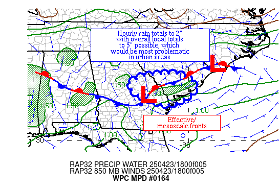
Mesoscale Precipitation Discussion 0164
NWS Weather Prediction Center College Park MD
328 PM EDT Wed Apr 23 2025

Areas affected...portions of eastern GA and southern SC

Concerning...Heavy rainfall...Flash flooding possible

Valid 231927Z - 240127Z

Summary...Thunderstorms with heavy rainfall have formed across
portions of eastern GA and southern SC.  Hourly rain totals to 2"
with overall totals to 5" are possible.

Discussion...An effective front is helping to foster increasing
convection from eastern GA across southern SC near and east of a
weak wave.  Precipitable water values of 1.3-1.4" lurk in this
region, as well as ML CAPE of 1000-2000 J/kg and effective bulk
shear of ~30 kts.  Water vapor imagery appears to show the region
at the base of a mid-level shortwave moving through the southern
Appalachians.  Radar imagery shows hourly rain totals near 2" as
of late due to either cell mergers or backbuilding, which should
be the maximum expected in this environment.  The highest local
overall total has been in the 5" range, which is also the maximum
expected.

The 18z RAP shows increasing convergence along the boundary,
particularly in southeast GA, over the next couple hours while the
weak wave recedes to the west-southwest.  The 12z HREF shows the
potential of heavy rainfall in this area for the next five hours.
Thereafter, CIN should develop after sunset and help shut down
convection.  Until then, hourly totals to 2" and overall totals to
5" are anticipated.  Flash flood guidance values are high as there
hasn't been much rainfall over the past week or two.  Any flash
flood issues that arise are expected to be in urban areas.

Roth

ATTN...WFO...CAE...CHS...FFC...

ATTN...RFC...SERFC...NWC...

LAT...LON   33738123 33668043 32987959 32038095 32358231
            32698297 33128336 33448294 33678205
Download in GIS format: Shapefile
| KML
Last Updated: 328 PM EDT Wed Apr 23 2025
