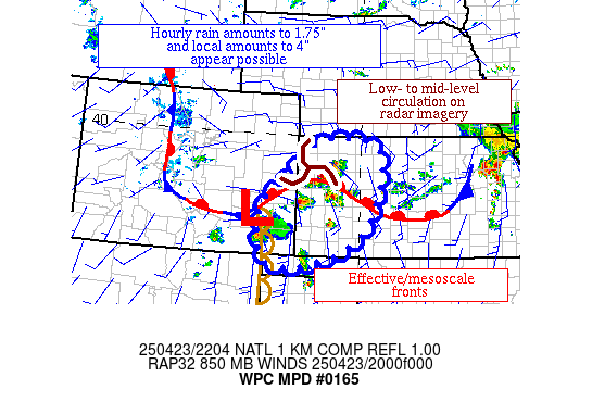
Mesoscale Precipitation Discussion 0165
NWS Weather Prediction Center College Park MD
607 PM EDT Wed Apr 23 2025

Areas affected...portions of western KS

Concerning...Heavy rainfall...Flash flooding possible

Valid 232206Z - 240406Z

Summary...Thunderstorms are increasing in coverage in and near
western KS.  Hourly rain amounts to 1.75" with local totals to 4"
are possible.

Discussion...The atmosphere in western KS is warming and becoming
uncapped (decreasing CIN) this afternoon as warm air advects in
from the south and southwest within the southern and southeast
quadrant of a retrograding circulation apparent on radar imagery
just southwest of Goodland KS.  Precipitable water values are
0.91" per Goodland's 21z sounding, moist for the High Plains.  ML
CAPE of 1500-2500 J/kg lies across the region.  Effective bulk
shear is 25-40 kts, which is enough to organize convection
linearly in a confluent way from the southwest.

Expectations are for increasing coverage for the next few hours
before activity attempts to accelerate east to northeastward.  The
mesoscale guidance has been showing upward trends in their QPF
since 12z across this region.  Interestingly, the mesoscale warm
front in western KS isn't expected to make much additional headway
northward, per recent RAP guidance, though ML CAPE does overrun it
some distance to the north.  Hourly rain amounts to 1.75" with
local totals to 4" appear possible where cells train or merge or
where occasional mesocyclones form and try to align.  There's a
wide range in the flash flood values across western KS, though the
area has been dry the past couple of weeks.  Any flash flooding is
more likely to be in urban areas.

Roth

ATTN...WFO...AMA...DDC...GID...GLD...PUB...

ATTN...RFC...ABRFC...MBRFC...NWC...

LAT...LON   39870111 39629940 37769975 36880117 36800291
            38110314 38840244
Download in GIS format: Shapefile
| KML
Last Updated: 607 PM EDT Wed Apr 23 2025
