Mesoscale Precipitation Discussion 0169
NWS Weather Prediction Center College Park MD
1000 AM EDT Thu Apr 24 2025

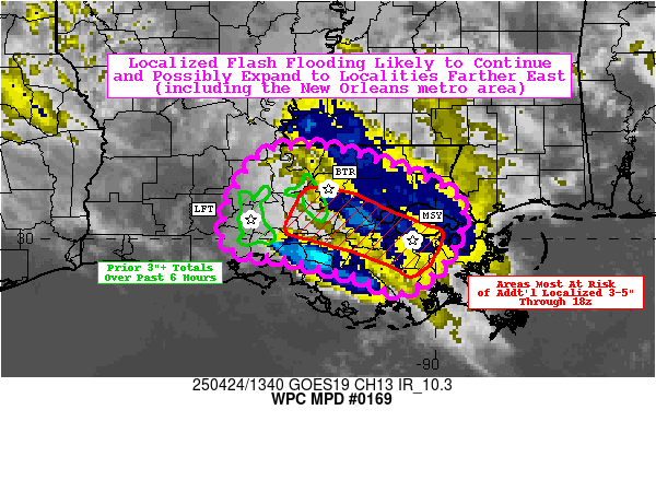
Areas affected...southeast LA

Concerning...Heavy rainfall...Flash flooding likely

Valid 241400Z - 241800Z

Summary...Localized flash flooding likely to continue and possibly
expand to localities farther east (including the New Orleans
metro) with additional isolated totals of 3-5" possible.

Discussion...A persistent cluster of thunderstorms from overnight
has grown into a mini MCS this morning, though GOES-East infrared
imagery indicates only sporadic cold cloud tops with a relatively
unimpressive appearance. Radar imagery tells a much different
story, as shallow updrafts have been incredibly persistent with
relatively slow storm motions (KHDC VWP indicating 10-20 kt
low-level flow), backbuilding along the southern and southwest
flanks, and upwind propagation towards the southeast (into the
low-level flow). With SPC's SFCOA analysis indicating PWATs of
1.5-1.7 inches (near the 90th percentile, per LIX sounding
climatology) and a reservoir of 500-1000 J/kg of ML CAPE directly
to the south and southeast, there are concerns that this small
convective complex will persist through the mid-morning to
mid-day. Crucially, the influence of the left exit region of a
subtropical jet streak (near 75 kts at 250 mb centered over South
TX) is providing both 20-25 kts of effective bulk shear and
enhanced upper-level difluence and lift. The persistence of the
convection (with the aforementioned occasional cold cloud tops
breaking through) suggests that the shear will continue to at
least irregularly support deep convection, and this feedback loop
allows for more rising motion and increased divergence aloft to
support further new updrafts and initiation. Localized areas with
the most efficient backbuilding and repeating of 1-3"/hr rainfall
rates has resulted in estimated hourly totals of as much as 2-4"
per MRMS (with KLFT recording back to back hours of 2.34" and
2.41" of rainfall earlier this morning). Past 6-hour MRMS
estimates indicate scattered totals of 3-6" (with some of the
heaviest and largest areas in the vicinity of the Lafayette and
Baton Rouge metro areas).

Hi-res CAM suites from 00z failed to capture virtually any of this
activity, though more recent hourly runs of the HRRR and RRFS have
done a much better job initializing and persisting convection
(with the RRFS notably catching on to this trend much earlier than
the HRRR). Analyzing these most recent model runs (10z onward)
going forward, the output QPF suggests the potential for
additional 3-5" localized amounts. As detailed above, the
short-term trends and current mesoscale environment supports these
amounts, and the heaviest amounts should continue to shift towards
the east with upwind propagation (potentially putting the New
Orleans metro area into greater threat over the next several
hours). Ongoing flash flooding (some significant and life
threatening) is likely to continue, possibly spreading eastward to
areas that have seen little to no rainfall thus far.

Churchill

ATTN...WFO...LCH...LIX...

ATTN...RFC...LMRFC...NWC...

LAT...LON   30989140 30879083 30709028 30388974 29808987
            29449035 29639090 29799159 29979225 30789197
Download in GIS format: Shapefile
| KML
Last Updated: 1000 AM EDT Thu Apr 24 2025
