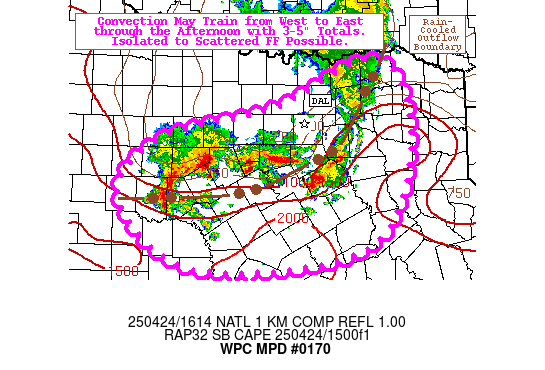
Mesoscale Precipitation Discussion 0170
NWS Weather Prediction Center College Park MD
1215 PM EDT Thu Apr 24 2025

Areas affected...portions of Central and North TX

Concerning...Heavy rainfall...Flash flooding possible

Valid 241615Z - 242215Z

Summary...Convection will have the potential to train from west to
east along and near and outflow boundary from overnight storms,
with 3-6 hour rainfall totals of 3-5" expected. Isolated to
scattered instances of flash flooding are possible.

Discussion...Redevelopment of deep convection has occurred in the
wake of a collision of two MCSs overnight into early this morning,
and cells are beginning to train/repeat along the remnant
rain-cooled outflow boundary. The mesoscale environment (per RAP
analysis) is characterized by SB CAPE of 500-2000 J/kg, PWATs of
1.3-1.5 inches (between the 90th percentile and max moving
average, per FWD sounding climatology), and deep layer shear of
30-40 kts. Short term trends favor continued thunderstorm
development and propagation towards the ESE @ 15-20 kts (per the
upwind propagation vector).

The 12z CAMs (HREF and experimental REFS suites) are in relatively
good agreement going forward, particularly the resulting
probability-matched mean (PMM) and 40-km neighborhood exceedance
probabilities between the two ensembles. This guidance suggests
localized 3-5" totals (per the PMM) with 3" and 5" exceedance
probabilities of 40-60% and 10-20%, respectively. The two ensemble
clusters are also in good agreement spatially, both centered near
the Heart of TX (with the HREF centered slightly to the west,
while the REFS is slightly farther east and north). The MPD area
covers a good bit of territory to the west and southwest of the
CAM footprints, owing to a typical northeast bias in the CAMs. The
short term trends support this shift (which would bring more heavy
precipitation into the more vulnerable northern reaches of the TX
Hill Country), and more recent runs of the HRRR have started to
catch on to this (while the individual RRFS runs are struggling
more to do so). Given the uncertainty in the ultimate evolution of
the convection, isolated to scattered flash flooding is considered
possible (as models and trends favor the bulk of the heaviest
precipitation over less vulnerable 6-hr FFGs of 3.0-5.0" over the
Heart of TX, though the DFW metro and into the TX Hill Country
have more vulnerable 6-hr FFGs of 2.0-3.0").

Churchill

ATTN...WFO...EWX...FWD...HGX...SHV...SJT...

ATTN...RFC...ABRFC...LMRFC...WGRFC...NWC...

LAT...LON   33769557 32599501 31029580 30759871 31760000
            32629931 33079733
Download in GIS format: Shapefile
| KML
Last Updated: 1217 PM EDT Thu Apr 24 2025
