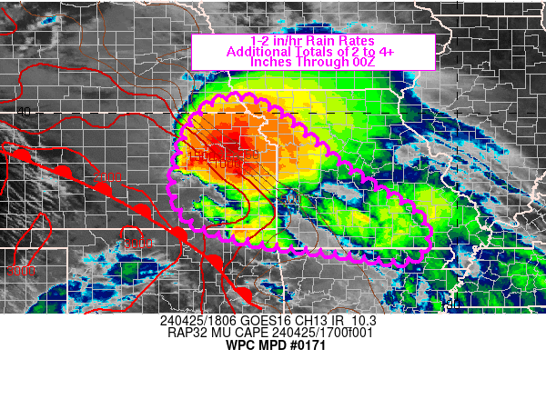
Mesoscale Precipitation Discussion 0171
NWS Weather Prediction Center College Park MD
508 PM EDT Thu Apr 24 2025

Areas affected...Southest NEB...Southwest IA...

Concerning...Heavy rainfall...Flash flooding possible

Valid 242110Z - 250230Z

SUMMARY...Slow moving, potentially back-building/training
thunderstorms near the old MCV poses a potential for a streak of
2-3" totals across SE NEB into SW IA and perhaps near urban
centers of Lincoln and  Omaha.

DISCUSSION...GOES-E VIS/WV/EIR suite denotes old MCV across SE NEB
slowly lifting northeastward.  The wave has helped to maintain a
weak inflection and surface to boundary layer confluence along
stationary front across S IA/N MO into SE NEB before
sharpening/angling southwest into north-central KS where
developing surface wave.  A pool of upper 50s/low 60s Tds in the
southeasterly confluent flow further adds to low level moisture
convergence along the boundary.   While deep layer mixing has
limited some MLCAPE, SBCAPEs have risen to the 2000 J/kg level and
the combination of the convergence near the surface is sparking
solid convective development over the last hour or so.

While winds are generally weak at 5-15kts though 850mb, quick
veering and strengthening in the 700-850mb layer has supported
localized effective bulk shear for stronger organization overall.
Orientation of the boundary and deeper layer steering flow (with
some backed mid-level inflow responding to the old MCV) may allow
for a favorable environment for redevelopment along the upwind
edge of northeast moving cells.  The movement should be generally
parallel to the boundary and may allow for some repeat/training
over the next few hours; though some downdrafts/cold pool
generation may deflect ideal training so trends will need to
watched closely.

While deep layer moisture is limited CIRA LPW shows enhanced
moisture in the 850-700 and 700-500mb layer at the northeast nose
of the encroaching EML to the south, pooling PWat Totals over
1.25" and slowly increasing should support increasing rainfall
efficiency with time toward 1.5"/hr.  Slow motions and training
will be key to localized spots of 2-3" totals in 1-3 hours through
the evening.  While hourly FFGs may be at the edge of exceedance,
the 2-3" totals over 3hrs are more probable of exceedance given
FFG values of 1.5-2.5"/3hrs across the area of concern.   As such,
an incident or two of flash flooding is considered possible this
evening with higher likelihood if cells track across urban centers
of Lincoln/Omaha given large impermeable surfaces in the area.

Gallina

ATTN...WFO...DMX...GID...OAX...

ATTN...RFC...MBRFC...NCRFC...NWC...

LAT...LON   42249500 41999428 41419436 40749546 40229647
            40029730 40119791 40429808 40859781 41219736
            41809638 42089565
Download in GIS format: Shapefile
| KML
Last Updated: 508 PM EDT Thu Apr 24 2025
