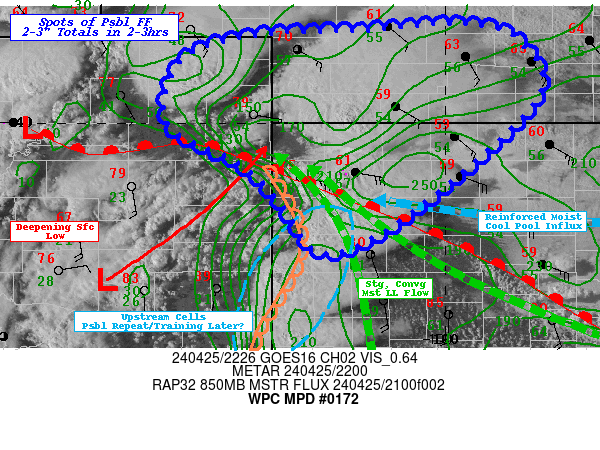
Mesoscale Precipitation Discussion 0172
NWS Weather Prediction Center College Park MD
729 PM EDT Thu Apr 24 2025

Areas affected...Northwest OK....Southwest to South-central KS...

Concerning...Heavy rainfall...Flash flooding possible

Valid 242330Z - 250400Z

SUMMARY...Storm scale influences and slow cell motions to
potentially enhance localized heavy rainfall threat across NW OK
with possible expansion of heavy rainfall/flash flooding potential
through early overnight period.

DISCUSSION...GOES-E Visible imagery shows a cluster of super cells
storms across Southwest KS into far Northwest OK.  Strong low
level shear environment has supported strong deep layer rotation
and increased isallobaric inflow of modest moisture within the
region.  23z surface analysis denotes cells are developing along a
fairly sharp west to east surface pressure trough with winds
responding as 15-20kts across the OK/TX panhandle veers toward the
convective axis, while winds are backed across Harper to Woods
county.  Solid upper 50s to low 60s Tds pooled into the
isallobarically influenced inflow to the cells allowing for
increased deep layer moisture and increasing rainfall efficiency.
Forward flank downdrafts/cold pools further steep effective
baroclinic zone resultant from W to E wetter and therefore cooler
surface/soil conditions from last night's heavy rainfall across
Meade to SW Barber county, KS further allow for FGEN/isentropic
ascent along a longer W-E axis with further overshooting tops
extending further eastward into Woods county, OK and upstream
back-building/flanking development across Seward/W Meade county.

Bunker's right moving propagation vectors suggest continued very
slow ESE propagation generally parallel to the active convective
line, this should result in some training/repeating over the
coming hours. Given total moisture of 1-1.2", localized saturation
of the low level profile will increase rates.  As such, recent
upward trend in rainfall output is noted in WoFS solutions from
90th percentile rainfall totals of 2", 3" and now over 4" with the
19z 21z and 22z runs, respectively (with mean values of 1"
increasing to 2.5") and generally aligns with current
observational trends noted in prior paragraph.   This provides
increasing confidence in the potential for localized 2-4" totals
across the area of concern. Given proximity to yesterday's
rain-foot and lowered FFG, flash flooding is considered possible
to continue/expand in areal coverage through the evening into the
early overnight period.

Gallina

ATTN...WFO...AMA...DDC...OUN...

ATTN...RFC...ABRFC...NWC...

LAT...LON   37510033 37499949 36829803 36209741 35859772
            35919851 36519956 37110041
Download in GIS format: Shapefile
| KML
Last Updated: 729 PM EDT Thu Apr 24 2025
