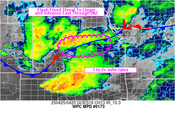
Mesoscale Precipitation Discussion 0173
NWS Weather Prediction Center College Park MD
1240 AM EDT Fri Apr 25 2025

Areas affected...central to northern KS

Concerning...Heavy rainfall...Flash flooding possible

Valid 250438Z - 250815Z

Summary...A flash flood threat will continue for central to
northern KS through at least 08Z. Rainfall rates of 1 to 2 in/hr
(locally higher) are expected with a general translation toward
the east over the next couple of hours.

Discussion...Thunderstorms have increased in coverage over
northern KS over the past 60-90 minutes, north of I-70, between
roughly longitude 100W to 96W. The environment contained 500-1000
J/kg MLCAPE (with slightly higher MUCAPE values) and little to no
CIN via 04Z SPC mesoanalysis data. Water vapor imagery identified
a subtle shortwave over central KS along with some upper
diffluence, tracking toward the east, which seemed to be
interacting with the unstable environment near a cold front at the
surface which was oriented from NE to SW across the state. Cells
contained a mixture of modes, including multicells, but overall
organization was lacking given limited bulk shear values. However,
individual cell motions were fairly slow with mergers and cell
training resulting in some chaotic movement in the short term and
some widely scattered exceedance of 1 and 3 hour flash flood
guidance values.

As the shortwave over central KS continues to advance off toward
the east within the larger scale westerlies, it is expected that
the disorganized cluster of ongoing cells over northern KS will
follow, into portions of northeastern KS where a relative max in
instability was estimated via SPC mesoanalysis data. Similar rain
rates of 1-2 in/hr are likely over the next 2-3 hours (though
locally higher will be possible), with areas of flash flooding
possible from 2-4 inches of rain. The expectation for beyond 08Z
to 09Z is that cell intensity will weaken as instability lowers as
the cold front continues to advance southward and overrunning
components of the low level flow diminish atop the boundary and
any outflow boundaries within the warm sector.

Otto

ATTN...WFO...DDC...GID...GLD...ICT...TOP...

ATTN...RFC...ABRFC...MBRFC...NWC...

LAT...LON   39889650 39749601 39379585 38689648 38429806
            38519935 39099990 39539962 39779876
Download in GIS format: Shapefile
| KML
Last Updated: 1240 AM EDT Fri Apr 25 2025
