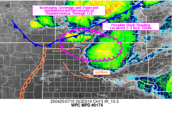
Mesoscale Precipitation Discussion 0174
NWS Weather Prediction Center College Park MD
332 AM EDT Fri Apr 25 2025

Areas affected...eastern OK Panhandle into southwest KS and
northwest OK

Concerning...Heavy rainfall...Flash flooding possible

Valid 250728Z - 251245Z

Summary...Elevated convection is expected to increase in coverage
across southwestern KS and possibly the OK Panhandle before likely
advancing southeastward into northwestern OK. There could be some
brief training and/or cell mergers which could result in 1-2 in/hr
rates and localized totals of 2-4 inches, along with localized
flash flooding.

Discussion...Regional radar imagery at 07Z showed a west-east axis
of thunderstorms over southwestern KS, southwest of DDC, which
appears to have formed on a cold frontal and/or remnant outflow
boundary. The surface analysis remains complex across the High
Plains early this morning with multiple boundaries tied to a
number of convective systems over the past 6-12 hours, including
rain-cooled air dropping in from the northwest over western KS.
Either way, the cells appear to be elevated with higher T/Td
located to the south over the TX Panhandle, east of a dryline
which extended southward into southeastern NM. The low level jet
is likely peaking in magnitude at this point in the night with
KAMA VAD wind data measuring 50-55 kt at 850 mb, with the nose of
these stronger winds reaching into southwestern KS early this
morning.

SPC mesoanalysis data from 06Z showed 1000 to 2000+ J/kg MUCAPE
over southwestern KS into the OK Panhandle with little to no CIN,
owing to low level moisture advection into the region due to the
low level jet and steep mid-level lapse rates over 8 C/km. Over
the next couple of hours, convective coverage is likely to expand
across southwestern KS and eventually propagate southeastward,
following Corfidi vectors and a similar path of an earlier MCS
which was located in central OK. That system produced 2 to 5+
inches (MRMS estimates) from Clark County, KS into Woods County,
OK since ~22Z Thursday. While the atmosphere has experienced some
overturning due to the earlier MCS which was located over central
OK at 07Z, some replenishment of instability on the nose of the
low level jet may support some renewed CAPE into portions of the
region, allowing for locally high rainfall rates.

Some overlap of expected rainfall through 12Z may overlap with
locations across southwestern KS into northwestern OK which picked
up heavy rain late Thursday, increasing the likelihood for renewed
flash flooding. Otherwise, flash flood guidance values varied
across the region but were as low as 2 inches in 3 hours for some
locations. While there remains uncertainty with the evolution of
the convection currently developing over southwestern KS, some
areas of flash flooding will be possible over the next few hours.

Otto

ATTN...WFO...AMA...DDC...ICT...OUN...TSA...

ATTN...RFC...ABRFC...NWC...

LAT...LON   38009975 37479790 36919682 36359680 35899720
            35669825 35719958 36100067 36670143 37250152
            37670111
Download in GIS format: Shapefile
| KML
Last Updated: 332 AM EDT Fri Apr 25 2025
