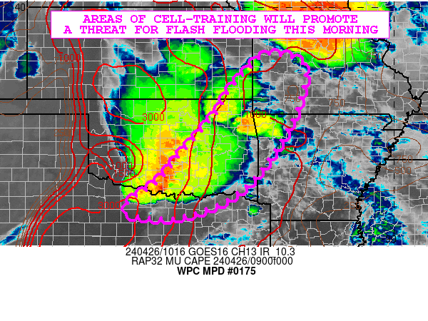
Mesoscale Precipitation Discussion 0175
NWS Weather Prediction Center College Park MD
840 AM EDT Fri Apr 25 2025

Areas affected...portions north-central MS into northwestern AL
and Middle TN

Concerning...Heavy rainfall...Flash flooding possible

Valid 251240Z - 251840Z

Summary...Intensifying thunderstorm activity will support 3-6 hour
localized totals as high as 3-5" through midday. Isolated to
scattered instances of flash flooding are possible.

Discussion...A cluster of thunderstorms is becoming more intense
and organized this morning over portions of the MS Delta,
supported by a mid-level shortwave/trough and enhanced low-level
convergence (southerlies from the Gulf and westerlies over the
Ark-La-Tex). While the influence of the subtropical jet to the
southwest is waning relative to the past few days, the
aforementioned shortwave is providing ample diffluence aloft as
the area is situated between the polar and subtropical jets. Per
SPC's SFCOA analysis at 12z, the mesoscale environment is
characterized by SB CAPE of 500-1500 J/kg over MS (with 500 J/kg
or less over north AL and Middle TN, but anticipated to increase),
PWATs of 1.4-1.8 inches (between the 90th percentile and max
moving average, per JAN sounding climatology), and effective bulk
shear near 20 kts. The combination of moderate instability, highly
anomalous moisture, and sufficient bulk shear should continue to
maintain relatively organized convection.

Hi-res CAMs are in relatively good agreement with regard to
expected localized amounts going forward, with both the 06z HREF
and 00z REFS probability-matched mean QPF indicating localized
totals as high as 2-3" (though the exact placement of these higher
totals varies quite a bit, as evidenced by 06z HREF and 00z REFS
Ensemble Agreement Scale 1" exceedance probabilities of 10% or
less). More recent runs (since 06z) of the HRRR have been quite a
bit more robust with QPF, indicating totals as high as 3-5"
through 18z (and the latest observational trends are supportive of
this, as convection is beginning to locally train from southwest
to northeast over portions of the MS Delta with MRMS hourly
estimates near 2.5"). With much of this QPF expected to fall in as
little as a 3-hr period, associated FFGs generally range from
1.5-3.0" (with 6-hr FFGs ranging from 3.0-5.0"). Isolated to
scattered instances of flash flooding are possible.

Churchill

ATTN...WFO...BMX...HUN...JAN...MEG...OHX...

ATTN...RFC...LMRFC...OHRFC...SERFC...NWC...

LAT...LON   35918727 35678623 34918587 33648730 32838905
            32829082 33449104 34069020 34408980 35308870
Download in GIS format: Shapefile
| KML
Last Updated: 840 AM EDT Fri Apr 25 2025
