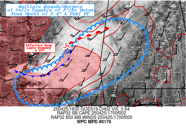
Mesoscale Precipitation Discussion 0176
NWS Weather Prediction Center College Park MD
245 PM EDT Fri Apr 25 2025

Areas affected...Northeast LA...Southern MS...Southwest AL...

Concerning...Heavy rainfall...Flash flooding possible

Valid 251845Z - 260030Z

SUMMARY...Clusters of slow moving thunderstorms in proximity to
older MCV across E MS may result in multiple rounds of intense
rainfall potentially resulting in widely scattered spots of 2-4"
inches inducing possible focused flash flooding.

DISCUSSION...Regional RADAR mosaic denotes an older mid-level MCV
along the southwestern flank of the main upper-level trough
exiting through the Lower Ohio Valley.  The subtle outflow jet to
the north continues to provide broad scale ascent to maintain the
vorticity center.  In the lower levels, this has resulted in solid
moisture/instability advection across the central Gulf within
solid WAA regime providing strong moisture flux convergence along
and downstream of the MCV.  Instability axis of 1000 J/kg across
central AL increases toward 2000 J/kg (MLCAPE) across the I-10
corridor from central LA toward southern AL providing solid
additional buoyancy for broader overturning even upstream along
the trailing southwest flank of the MCV/confluence axis.   Deep
layer moisture lags a bit to the west of the instability with
1.5-1.7" total PWat Valleys but proximity and solid surface Tds
values in the lower 70s to allow for efficient rainfall production
for the cells.  The combination should allow for rates of
1.5-2"/hr.

Cells in the warm sector of the wave will remain slow moving
waiting for the upstream forcing/inflow may result in hour or so
duration. Minus a small zone of reduced FFG across E MS north of
Meridian, FFG values are likely not to be exceeded given totals of
2-2.5" with the first round.  However, given increasing density of
coverage, potential for mergers and a secondary bout of similar
intense rates may result in more scattered areas reaching 2-3.5"
over a 3hr period and potentially result in localized incident or
two of flash flooding.

Further southwest across E LA/SW MS, winds are likely to respond
with confluent veering as the MCV continues to press eastward.
500-1000mb thickness suggestion some increased spread and
therefore reduced propagation vectors toward the southeast though
the late afternoon into evening hours.   Additionally, any outflow
boundary is more probable to orient NW to SE and be a bit more
orthogonal to the veered low level flow resulting in some
potential for back-building, though with weaker/weakening flow
convergence may become more scattered in nature.  Slower cell
motions at the trailing edge, also suggest increased duration for
spots of 2-4" here as well.  Proximity to I-10 and urban locales
that dot along it, further increase potential for possible
incidents of flash flooding as well.

Gallina

ATTN...WFO...BMX...JAN...LIX...MOB...

ATTN...RFC...LMRFC...SERFC...NWC...

LAT...LON   33578771 33268690 32528676 31868722 31248809
            30548963 30439051 30589140 31419153 31969013
            33028910 33448844
Download in GIS format: Shapefile
| KML
Last Updated: 245 PM EDT Fri Apr 25 2025
