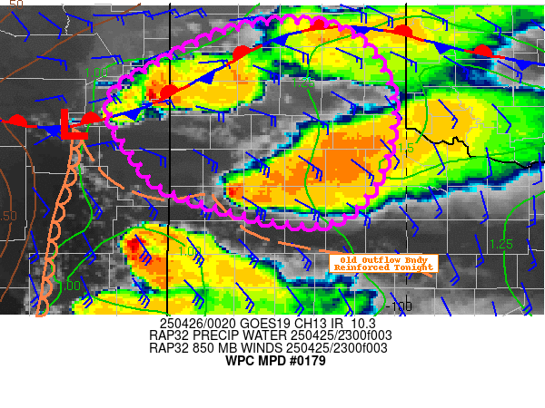
Mesoscale Precipitation Discussion 0179
NWS Weather Prediction Center College Park MD
839 PM EDT Fri Apr 25 2025

Areas affected...Texas Panhandle and Cap Rock...Adj East-Central
NM...

Concerning...Heavy rainfall...Flash flooding likely

Valid 260040Z - 260600Z

SUMMARY...Upscale growth from individual supercells toward
clusters and small complexes is expected to increase rainfall
efficiency and expand areas of intense rainfall rates/totals
through early overnight period.   Spots of 3-5" are possible and
more incidents of flash flooding will be likely.

DISCUSSION...00z Surface analysis denote a surface low WNW of
Clovis with slowly retrograding dry line extending southward
across SE NM toward ROW/ATS and CNM.  A strong and steepening
frontal zone extends from the low northeastward toward the
Canadian River Valley northeast of AMA to BGD and HHF before
sagging southward again across central OK.  Low level moisture
continues to stream eastward and while sfc Tds have remained in
the upper 50s/low 60s, the depth of moisture continues to increase
as PWat values have risen a few tenths in the last few hours,
though still remain greatest/pooled along and south of the frontal
boundary through the upper Red River valley where values are over
1.5".  VWP shows LLJ is starting to increase from 850 to 700mb
with that moisture return with lower winds increasing into the
lower 30 kt range from the southeast but southerly flow at 700 is
about 20-25 kts.

As such, moisture flux convergence from 850-700mb is starting to
maximize along the front and convective activity has perked up in
the last hour or so, expanding across toward the surface low in
eastern NM.  While KDP/ZDR suggests large hail currently remains
main threat, there is expanding moderate to heavy rainfall
signatures as the overall near storm profile continues to
moisten/saturate especially in the lowest levels.  This will
increase rainfall efficiency from supporting 1-1.5"/hr rates
currently toward 2"/hr after night fall occurs.

Additionally, RAP forecast along with some suggestion in GOES-E WV
loop (and AMVs) suggest a broadening diffluent region toward the
jet occurring over the TX Panhandle.  This is expected to expand
with increasing divergence aloft through 06z as it slowly shifts
eastward.  This will further enhance confluent low level moisture
flux toward other developing clusters into a few smaller
complexes.  Slow forward cell motions and storm scale interactions
suggest cell mergers and increased duration at given locations.
As such, there remains a solid signal of spots of 3-5" totals and
given recent rains and FFG values of 1.5-2"/hr and 1.5-3"/3hrs it
is considered likely that localized flash flooding concerns will
continue into early overnight period.

Gallina

ATTN...WFO...ABQ...AMA...LUB...

ATTN...RFC...ABRFC...WGRFC...NWC...

LAT...LON   35930148 35800077 35360033 34710017 33860040
            33380094 33410180 33760301 34100340 34880381
            35380318 35800230
Download in GIS format: Shapefile
| KML
Last Updated: 839 PM EDT Fri Apr 25 2025
