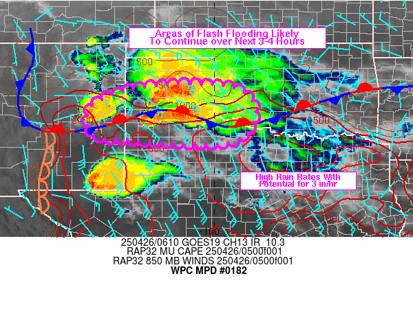
Mesoscale Precipitation Discussion 0182
NWS Weather Prediction Center College Park MD
222 AM EDT Sat Apr 26 2025

Areas affected...TX Panhandle into northwestern TX/southwestern OK

Concerning...Heavy rainfall...Flash flooding likely

Valid 260620Z - 261030Z

SUMMARY...Areas of flash flooding will be likely from portions of
eastern NM into and across the TX Panhandle into northwestern
TX/southwestern OK. Slow movement of heavy rain cores will be
capable of producing rainfall rates of 2 to 3+ in/hr as the threat
gradually builds east over the next 3-4 hours.

DISCUSSION...06Z radar imagery from the TX Panhandle showed an MCS
with an embedded MCV attempting to become better organized over
the TX Panhandle near Amarillo. MLCAPE and MUCAPE values were
estimated to be 1000-2000 J/kg (higher values to south), PWATs of
1 to 1.5 inches and effective bulk shear values of 30+ kt (via SPC
mesoanalysis data). This environment has been supportive of
organized supercells with varying motions and spotty very heavy
rain with observed rainfall rates locally in excess of 3 in/hr.
Individual cell organization has become a bit poorer near/north of
a quasi-stationary front but farther south, a supercell was noted
west of I-27 near Earth and the environment remains capable of
organized cells. In addition, the heavy rainfall threat was
maintaining significance with cooling still noted on infrared
cloud tops. 850 mb winds were southeasterly at 25-35 kt over the
southern Panhandle, advecting moisture and instability into the
convective complex over the Panhandle.

Forecast Corfidi Vectors suggest a general eastward motion to the
MCS should continue in the short term through additional
convective development is probable along convergence tied the
southward sagging frontal boundary over northwestern TX and
moderately strong low level flow into the boundary where
uninhibited instability was present. The result will be an
expansion of convective coverage with embedded elements of
training, slow and erratic individual cell motions and merging of
heavy rain cores which will likely result in continued high
rainfall rates, possibly exceeding 3 in/hr. Portions of
northwestern TX have received heavy rain over the past 3 days and
are locally more susceptible to flash flooding from heavy
rainfall.

Otto

ATTN...WFO...ABQ...AMA...LUB...OUN...

ATTN...RFC...ABRFC...WGRFC...NWC...

LAT...LON   35589989 35339903 34709859 33839904 33580005
            33660195 33730291 33890411 34900414 35520234
Download in GIS format: Shapefile
| KML
Last Updated: 222 AM EDT Sat Apr 26 2025
