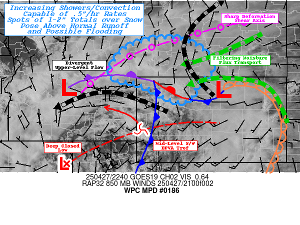
Mesoscale Precipitation Discussion 0186
NWS Weather Prediction Center College Park MD
650 PM EDT Sun Apr 27 2025

Areas affected...Northwest WY...South-central MT...

Concerning...Heavy rainfall...Flash flooding possible

Valid 272250Z - 280430Z

SUMMARY...Increasing convective activity along/south of sharp
stationary deformation zone will allow for slowly increasing
rainfall rates and localized totals up to 2" through early
overnight period.  Rain over snow pack will further increase
runoff and the potential for flooding conditions.

DISCUSSION...An anomalous deep closed low across the Great Basin
has a strong vorticity center rotating along the northeastern
quadrant across the north-central Rockies of WY and ID.  Both GOES
WV suites show a highly divergent mid to upper-level pattern
across southern MT enhancing the deformation shear axis from
central ID across SW to central MT. A similarly sharp 500-1000
thickness ridge extending across SE MT to the northern High
Plains, suggestive of very slow propagation vectors and convergent
deep layer steering flow along the downshear side of the deep
upper-low in the area of concern.   Strong dynamic ascent will
need to overcome limited instability warm/moist air in the lower
profile and utilize slant-wise ascent toward the deformation zone.
 However, a ribbon of low to mid-level moisture has been trying to
bleed through the terrain of south-central MT into northwest WY
with Tds into the low 40s supporting .25 to .5" low level PWat
values.

As the main forcing lifts north an 850-700mb cyclone is deepening
across northern WY which has further strengthened low level
northeasterly flow convergent with southerly flow along/ahead of
the synoptic cold front starting to press through W WY/E UT at
this time.  So solid moisture flux will continue from the east and
deeper source throughout the evening into the early overnight
period.  Already, the deep layer convergence is utilizing
available moisture with convective towers seen breaking through
the cirrus canopy across south-central MT with increasing
lightning noted.  Given the stationary deformation zone and
increased convergence, cell motions will be limited or even
stationary with potential of increasing upstream mergers
throughout the evening.  So while intensity of .25-.5"/hr is
expected (with some HREF probability nearing 50% for 1"/hr rates,
driven mainly by the NAM-Nest) these rates are falling in
proximity to some warming snow pack that will also add to the
runoff and potential flooding concerns through the evening with
localized totals of 1-2" possible.  Even where snow has melted,
NASA SPoRT 0-40cm soil saturation values are running well above
normal and over 70-80% across areas north of YNP.  As such,
localized flooding is considered possible through the evening into
early overnight hours.

Gallina

ATTN...WFO...BYZ...RIW...TFX...

ATTN...RFC...MBRFC...NWC...

LAT...LON   46790966 46640866 46060778 45300753 44850810
            44120844 43910862 43860911 44090974 44481043
            44781126 44911207 45341225 45801200 46321153
            46631078
Download in GIS format: Shapefile
| KML
Last Updated: 650 PM EDT Sun Apr 27 2025
