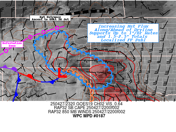
Mesoscale Precipitation Discussion 0187...Corrected
NWS Weather Prediction Center College Park MD
735 PM EDT Sun Apr 27 2025

Corrected for Southeast MT in Areas Affected Line

Areas affected...Southeast MT...Western SD...Northeast WY...

Concerning...Heavy rainfall...Flash flooding possible

Valid 272330Z - 280500Z

SUMMARY...Slow moving increasingly efficient thunderstorms capable
of 1"/hr and spots of 1.5-2.5" totals in less than 3hrs posing
possible localized incidents of flash flooding

DISCUSSION...Surface analysis at 23z, shows a deepening sub-1000mb
surface low between BYG and GCC in northeast WY bulging eastward
along the western edge of the Black Hills before dropping south
through the NEB panhandle toward secondary wave near TOR.  Surface
Tds of mid to upper 50s are wrapping around and through the Black
Hills and trying to draw westward along and north of the bulge
across SE MT.  Full heating along/ahead of the wave and solid DPVA
aloft from approaching upper-level trough within the eastern
quadrant of the deep upper low over the Great Basin and the low
level moisture is resulting in solid instability numbers, even to
1500 J/kg as far west as Big Horn county, MT.  As such,
convergence along the bulging dry line and easterly flow north of
the low has lead to a cluster of strong severe thunderstorms
across SE MT.  While hail is main concern, there is ample moisture
flux to support increasing rainfall production.

Given proximity to a sharp 500-1000 thickness ridge and generally
weaker steering flow in proximity to a sharp deep layer
deformation zone across central to northeast MT, even though
organization, cells will be slow moving allowing for .5"/hr rates
to slowly increase toward 1"/hr rates in the coming hours as deep
layer moisture flux increases Total Pwats from .75-1" to 1-1.25".
Below average/early season FFG values are within reach for
1-1.5"/hr and 1-2"/3hrs across SE MT into the Black Hills of SD.
Eventually cold pools should generate and low level flow will veer
in proximity to the dry line bulge and cell motions/propagation
will become more easterly, still duration may allow for some spots
of 1.5-2.5" totals though early overnight period across the area
of concern and so isolated incidents of flash flooding are
considered possible.

Gallina

ATTN...WFO...BYZ...GGW...UNR...

ATTN...RFC...MBRFC...NWC...

LAT...LON   47780660 47600599 46880600 46390542 45730365
            44950276 44130242 43500324 43640421 44500518
            44790632 44930698 45120728 45750749 45900757
            46450817 46790850 47160826 47450764
Download in GIS format: Shapefile
| KML
Last Updated: 735 PM EDT Sun Apr 27 2025
