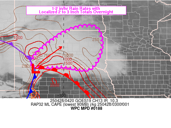
Mesoscale Precipitation Discussion 0188
NWS Weather Prediction Center College Park MD
1235 AM EDT Mon Apr 28 2025

Areas affected...NE/SD border into central/northern SD

Concerning...Heavy rainfall...Flash flooding possible

Valid 280432Z - 280930Z

Summary...Widely scattered instances of flash flooding will be
possible from the NE/SD border into central/northern SD and far
southeastern ND through 09Z. Short term training of organized
cells and areas of heavy rain will support 1 to 2 in/hr rainfall
rates and localized totals near 3 inches.

Discussion...04Z surface observations placed a triple point low
just southeast of Pine Ridge, SD with a trailing cold front
co-located with line of thunderstorms extending southward through
western NE. A cyclic supercell was located east of the surface low
in Cherry County, NE along a warm front with elevated
thunderstorms north of the warm front into south-central SD. The
frontal cyclone was related to a large closed mid/upper low
crossing the Intermountain West, with highly favorable upper level
jet induced divergence and diffluence across the central SD/NE
border. SPC mesoanalysis data showed anomalous moisture in place
over SD with PWATs between 1 and 1.2 inches and MLCAPE was
estimated to be between 500 to 1500 J/kg along the central SD/NE
border with elevated instability of 1000 to 1500+ extending
northeastward into east-central SD.

The track of the surface low is forecast by the RAP to advance
into central SD by 09/12Z with advection of low level moisture and
strong lift helping to erode the capping inversion seen on the 00Z
ABR sounding. The ABR sounding indicated 700-500 mb lapse rates of
9.1 C/km which should support strong updrafts into the overnight.

Deeper layer steering flow form the SW will allow for some areas
of short term training as the triple point low and related fronts
advance into SD over the next few hours, with low level
convergence aligned with cell motions. Rainfall rates of 1-2 in/hr
are expected which could produce some 2 to 3+ inch totals and
widely scattered instances of flash flooding given flash flood
guidance values of 1.5 to 2.5 inches in 3 hours present across
much of SD.

Otto

ATTN...WFO...ABR...BIS...FGF...FSD...LBF...OAX...UNR...

ATTN...RFC...MBRFC...NCRFC...NWC...

LAT...LON   46179863 46129736 45199698 44029708 42799796
            43000005 42950195 43240265 44290188 45560021
Download in GIS format: Shapefile
| KML
Last Updated: 1235 AM EDT Mon Apr 28 2025
