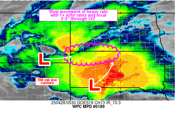
Mesoscale Precipitation Discussion 0189
NWS Weather Prediction Center College Park MD
145 AM EDT Mon Apr 28 2025

Areas affected...western ND/SD border

Concerning...Heavy rainfall...Flash flooding possible

Valid 280544Z - 281140Z

SUMMARY...Isolated flash flooding will be possible in the vicinity
of the western ND/SD border from slow movement of heavy rain over
the next 3-6 hours. Rainfall rates occasionally exceeding 1 in/hr
are expected to lead to spotty 2-3 inch totals through 12Z.

DISCUSSION...GOES East infrared imagery and lightning data showed
the slow eastward movement of a small cluster of thunderstorms
which was located near the tri-state region of MT/ND/SD at 0520Z.
A combination of 700 mb VAD wind plots, 850-700 mb LPW imagery
along with RAP analysis data showed the upper level reflection of
two surface lows over the High Plains. Using 700 mb as a
representative level, the low centers were located over
southeastern MT and southwestern SD, with a general weakness in
the 850-300 mb steering flow near and southeast of the tri-state
region. MUCAPE of approximately 500-1000 J/kg was in place from
the eastern MT/WY border into the western ND/SD border via 05Z SPC
mesoanalysis data.

The weakness in the deeper layer flow is forecast by the RAP to
maintain and perhaps deamplify the winds even more through 12Z
across the region (as low as 5 kt). The weakness aloft will
continue to allow for slow movement of heavy rain cores from along
and east of the MT/ND/SD intersection into southwestern ND and
northwestern SD. Instability values are likely to weaken as lower
levels of the atmosphere cool in the wake of the stronger low over
SD which is forecast to track northeastward, resulting in moisture
wrapping around to the north and west of the low into an elongated
commahead/deformation zone which will contain embedded heavy
rainfall rates.

The potential for hourly rainfall of 1 to 1.5 in/hr will be
greatest through ~08Z, after which point the reduction in
instability values should reduce rainfall intensity to a more
steady/longer duration rainfall event. Through ~12Z, spotty
additional rainfall totals of 2-3 inches will be possible which
may support some isolated flash flooding.

Otto

ATTN...WFO...ABR...BIS...BYZ...UNR...

ATTN...RFC...MBRFC...NWC...

LAT...LON   46360150 45950026 45390049 45060185 44990334
            45260426 45930437 46270349
Download in GIS format: Shapefile
| KML
Last Updated: 145 AM EDT Mon Apr 28 2025
