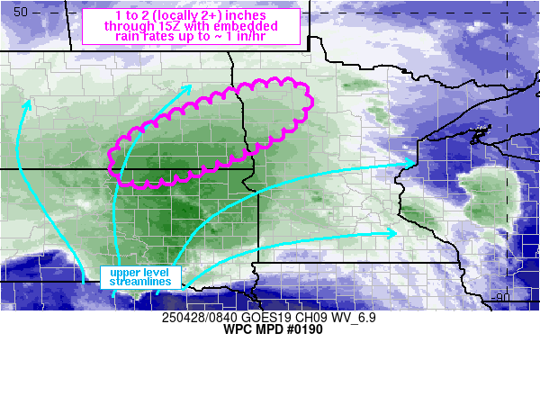
Mesoscale Precipitation Discussion 0190
NWS Weather Prediction Center College Park MD
501 AM EDT Mon Apr 28 2025

Areas affected...southeastern ND into northwestern MN

Concerning...Heavy rainfall...Flash flooding possible

Valid 280900Z - 281500Z

SUMMARY...Steady rain with embedded rain rates of 0.5 to about 1
in/hr are expected to affect portions of southeastern ND into
northwestern MN through 15Z. While rainfall intensity should
remain relatively low, total rainfall 1 to 2 (locally 2+) inches
may result localized areas of runoff.

DISCUSSION...0850Z water vapor imagery and MRMS reflectivity
showed the manifestation of a low to mid-level vorticity max over
east-central SD, slowly advancing toward the NNE. Anomalous
moisture was present with recent GPS data indicating 1.0 1o 1.1
inches near FSD, with northward extrapolation using SPC
mesoanalysis and sounding climatology data, suggests moisture
across the Red River of the North was over the 90th percentile.
GOES East derived winds and short term RAP forecasts highlighted
an 80-100 kt jet max positioned over northeastern CO into central
NE with left-exit region induced diffluence and divergence over SD.

As the low to mid-level low/vort over central SD moves north,
favorable ascent will overspread eastern ND into western and
northern MN within a SW to NE oriented deformation zone which is
expected to slowly pivot over eastern ND. 850 mb winds to the east
of the main surface low will continue to advect anomalous moisture
northward which will wrap back into the cold conveyor
precipitation axis where weak instability (up to 500 J/kg) should
be present per recent RAP forecasts. The combination of the
anomalous moisture, strong ascent and weak instability should be
enough to support localized rainfall rates of 0.5 to about 1 inch
per hour at times, with a longer duration heavy rainfall axis
impacting southeastern ND into northwestern MN through 15Z.
Localized totals within this axis of 1-2 inches are expected, and
localized totals in excess of 2 inches will be possible along with
localized flash flooding given possible exceedance of the 1,3 and
6-hour FFG.

Otto

ATTN...WFO...ABR...BIS...FGF...

ATTN...RFC...MBRFC...NCRFC...NWC...

LAT...LON   48139576 47819517 47039572 46129752 45639924
            45820012 46460006 47019919 47849716
Download in GIS format: Shapefile
| KML
Last Updated: 501 AM EDT Mon Apr 28 2025
