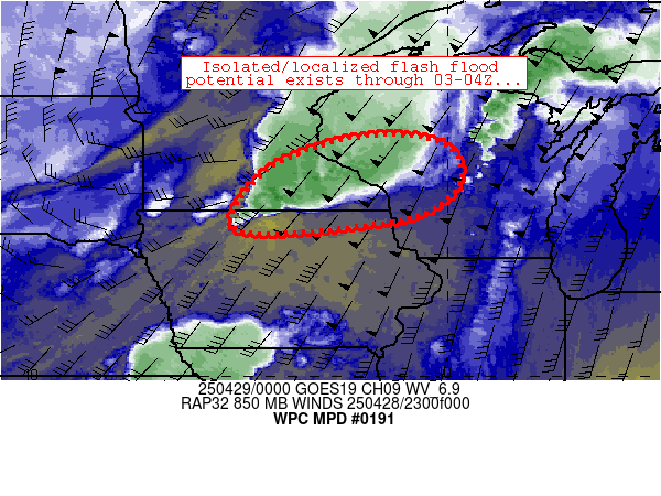
Mesoscale Precipitation Discussion 0191
NWS Weather Prediction Center College Park MD
811 PM EDT Mon Apr 28 2025

Areas affected...northern Iowa, southeastern Minnesota, western
Wisconsin

Concerning...Heavy rainfall...Flash flooding possible

Valid 290011Z - 290411Z

Summary...Isolated flash flooding could occur as a convective
complex migrates eastward across the region tonight.

Discussion...Scattered convection that had initially developed
across southwestern Minnesota has grown upscale into loosely
organized linear segments, with a bow structure noted southwest of
Eau Claire, WI.  Southwest of this bowing segment, cells were
gradually maturing along an axis from near Rochester, MN
southwestward to north-central Iowa near Emmetsburg.  Trailing
convection southwest of the bow has exhibited a favorable setup
for convective training.  Cooler surface temperatures (in the 50s)
northwest of the training axis is indicative of a maturing cold
pool that could interact favorably with southwesterly 850mb flow
to maintain convergence and new updrafts streaming into the
training axis for another 2-3 hours or so.  This scenario should
help to maintain ongoing 1-1.5 inch/hr rain rates (estimated per
MRMS) where convective training is most pronounced, leading to
isolated spots of FFG exceedence and flash flooding.

This scenario should be relatively short-lived, however.  Models
suggest that 850mb flow will veer gradually to westerly through
03-04Z, which should act to limit training potential by decreasing
convergence along the edge of the aforementioned cold pool.  As
long as convective training persists, isolated flash flooding will
be possible.

Cook

ATTN...WFO...ARX...DMX...GRB...MPX...

ATTN...RFC...NCRFC...NWC...

LAT...LON   45109092 44738987 43928987 43299109 43089444
            44229398 44909261
Download in GIS format: Shapefile
| KML
Last Updated: 811 PM EDT Mon Apr 28 2025
