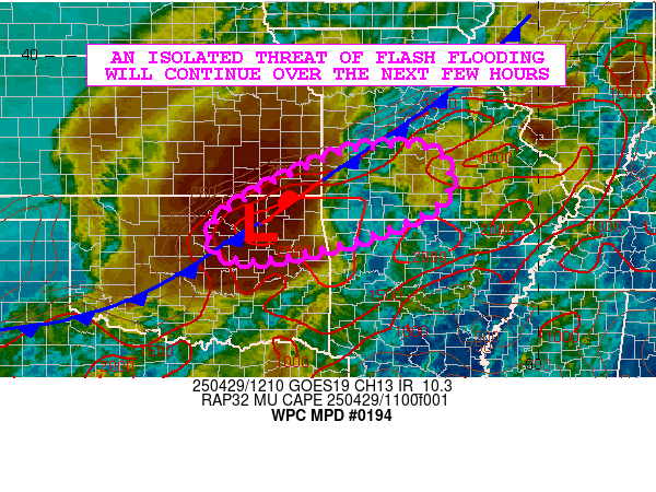
Mesoscale Precipitation Discussion 0194
NWS Weather Prediction Center College Park MD
830 AM EDT Tue Apr 29 2025

Areas affected...Northeast OK...Far Southeast KS...Southwest
MO...Far Northwest AR

Concerning...Heavy rainfall...Flash flooding possible

Valid 291230Z - 291700Z

SUMMARY...A strong complex of showers and thunderstorms will
continue to advance off to the east over the next few hours. A
concern for isolated areas of flash flooding will continue.

DISCUSSION...GOES-E IR satellite imagery shows a mature,
cold-topped MCS advancing eastward across central to northeast OK
and into far southeast KS. The convection is focusing in close
proximity to a wave of low pressure riding northeastward up along
a strong frontal zone, with a corridor of rather strong moisture
convergence in place. Additionally, there is a fair amount of
instability in place at least in a somewhat elevated fashion with
MUCAPE values of close to 2000 J/kg.

A southwest low-level jet of 30 to 40 kts should tend to help
sustain the convective complex at least for a few more hours as it
advances downstream into areas of southwest MO and possibly far
northwest AR. The PW environment is somewhat moist with values of
around 1.5 inches, and this coupled with the organized nature of
the convection should tend to favor rainfall rates continuing to
reach well into the 1 to 2 inch/hour range.

The latest hires model guidance suggests some localized 2 to 4
inch rainfall totals may be possible where at least some brief
cell-training occurs in close proximity to the aforementioned
front.

This will be occurring over areas of the Ozark Plateau that are
rather moist from an antecedent conditions perspective.
Streamflows especially across southwest MO are generally running
above normal this morning, and these additional rains may favor
some more efficient runoff concerns. Thus, at least an isolated
threat of flash flooding will continue to be attached to this
convective complex over the next few hours.

Orrison

ATTN...WFO...ICT...LZK...OUN...SGF...TSA...

ATTN...RFC...ABRFC...LMRFC...MBRFC...NWC...

LAT...LON   37979386 37939220 36989202 36279334 35829505
            35659624 35929694 36519683 37289562
Download in GIS format: Shapefile
| KML
Last Updated: 830 AM EDT Tue Apr 29 2025
