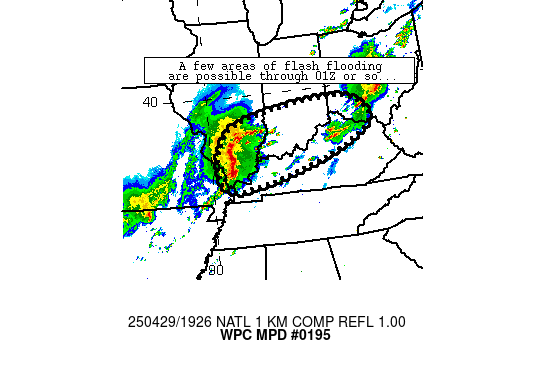
Mesoscale Precipitation Discussion 0195
NWS Weather Prediction Center College Park MD
329 PM EDT Tue Apr 29 2025

Areas affected...southeastern Illinois, southern indiana, far
northern Kentucky, and southwestern Ohio

Concerning...Heavy rainfall...Flash flooding possible

Valid 291927Z - 300127Z

Summary...Isolated spots of flash flooding are possible as a
convective complex migrates from southern Illinois across the
discussion area through 01Z/8pm CDT.

Discussion...Strong convection has aligned in a mostly linear
fashion across southern Illinois from near Mount Vernon to near
Cape Girardeau.  This complex was moving east at around 30-35
knots.  More recently, radar mosaic imagery has depicted lead
cells developing out ahead of the main linear complex in more of a
east-west orientation (parallel to flow aloft).  These cells have
merged with the main complex, allowing for localized prolonging of
heavier rainfall and rates peaking at around 1.5-2 inch/hr (per
MRMS), which has locally exceeded hourly FFG.  A couple instances
of flash flooding have been reported near the cell mergers over
the past 30-60 minutes or so just southwest of Nashville, IL.

The overall regime will shift eastward across the discussion area,
traversing the Ohio Valley and adjacent areas of IL/IN/KY and
southwestern OH through 01Z.  The regime is expected to continue
to produce spots of 1.5 inch/hr rain rates that could result in
localized flash flooding at times especially where cell mergers
are most frequent.  Current trends suggest that the greatest flash
flood risk should enter southern Indiana after around 21Z or so,
and southwestern Ohio after around 23-00Z.

Cook

ATTN...WFO...ILN...ILX...IND...JKL...LMK...LSX...PAH...

ATTN...RFC...LMRFC...NCRFC...OHRFC...NWC...

LAT...LON   39618410 39078322 38478345 37728508 36998796
            36928939 37888971 38888916 39318789 39608588
Download in GIS format: Shapefile
| KML
Last Updated: 329 PM EDT Tue Apr 29 2025
