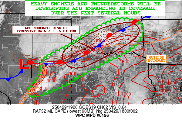
Mesoscale Precipitation Discussion 0196
NWS Weather Prediction Center College Park MD
336 PM EDT Tue Apr 29 2025

Areas affected...West-Central to Northwest TX...Southwest to
Central OK

Concerning...Heavy rainfall...Flash flooding likely

Valid 291935Z - 300135Z

SUMMARY...Considerable development and expansion of heavy showers
and thunderstorms can be expected over the next several hours
going into the evening time frame. Areas of flash flooding will
become likely in time due to heavy rainfall rates and storm totals
along with locally sensitive soil/streamflow conditions.

DISCUSSION...The mid-afternoon GOES-E visible satellite imagery
shows convection beginning to initiate across areas of western TX
in close proximity to the dryline, with additional agitated CU/TCU
development noted off to the northeast near a stationary front
situated over northwest TX and into southwest and central OK. In
fact, there is a cluster of stronger convection evolving over
central OK to the south of the Oklahoma City metro area which is
near the intersection of the front and a nearby long-lived outflow
boundary.

The warm sector airmass across the southern Plains near these
boundaries is quite unstable with MLCAPE values of 2000 to 2500+
J/kg in place with the aid of strong diurnal heating and a
moisture-laden boundary layer with surface dewpoints in the mid to
upper 60s. A substantial amount of shear is already in place with
effective bulk shear values of 50 to 60+ kts noted, and this
coupled with the favorable thermodynamic environment will set the
stage for developing and expanding clusters of heavy showers and
thunderstorms over the next few hours.

Given the arrival of subtle height falls from the west in
association with a deep upper trough over the Southwest, and with
some additional strengthening of the low to mid-level wind field,
the convection should grow upscale heading into the evening hours
with well-organized convection focusing near the dryline and
especially the front/outflow boundary locations. This will include
supercell thunderstorm activity with potential for cell-mergers
and potentially some smaller scale QLCS evolution in time.

The environment will be rather moist by this evening across the
region and especially over northern TX and into southern OK where
PWs should increase to near or above 1.5 inches and this will be
running a solid 2 standard deviations above normal. This coupled
with the kinematic and thermodynamic environment should help
support rainfall rates as high as 1.5 to 2.5"/hour with the
stronger convective cores, and especially any supercells.

In time, the upscale growth along with concerns for cell-mergers
and localized cell-training will favor some storm totals by early
this evening of 3 to 5 inches. The heaviest rainfall totals are
expected to be over areas of northwest TX into southwest and
south-central OK and this closely aligns with the current WPC D1
ERO depiction of a Moderate Risk of excessive rainfall. Areas of
flash flooding are expected to gradually become likely across
these areas, and especially given elevated soil/streamflow
sensitivities.

Orrison

ATTN...WFO...FWD...LUB...MAF...OUN...SJT...TSA...

ATTN...RFC...ABRFC...WGRFC...NWC...

LAT...LON   36489622 36179484 35469462 34559520 33889625
            33269753 32199944 31610038 30810235 30700312
            30960329 31850260 32510223 33110226 33680167
            34340032 35129907 36029763
Download in GIS format: Shapefile
| KML
Last Updated: 336 PM EDT Tue Apr 29 2025
