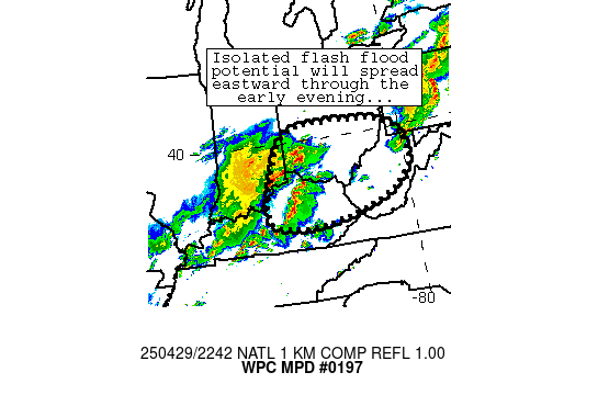
Mesoscale Precipitation Discussion 0197
NWS Weather Prediction Center College Park MD
644 PM EDT Tue Apr 29 2025

Areas affected...northern Kentucky, southeastern Indiana, southern
Ohio, portions of West Virginia

Concerning...Heavy rainfall...Flash flooding possible

Valid 292244Z - 300244Z

Summary...Loosely organized convective clusters continue to
migrate eastward and produce spots of 1 inch/hr rain rates.  These
trends are expected to continue through/after sunset, posing a
risk of isolated flash flooding.

Discussion...Scattered convection has developed in earnest across
portions of southwestern Ohio and Kentucky out ahead of a MCS over
southern Indiana.  Heavier rain rates associated with this
convection have decreased somewhat - mainly due to a lesser degree
of organization of the convection compared to just a couple hours
ago.  Nevertheless, spots of 1 inch/hr rain rates continue to be
estimated per MRMS as cells merge/train on a localized basis.
Storms are being maintained by a moist, uncapped, and unstable
airmass characterized by 1.6 inch PW values and ~1500 J/kg MLCAPE
away from cold pools.  Additionally, 25-35 kn westerly flow was
allowing for efficient recovery of the airmass across Ohio in the
wake of a strong MCS that traversed that area, indicating
potential for eastward persistence of storms into OH/WV through
the early evening.

Cells should also gradually move into areas with slightly lower
FFG thresholds (around 1 inch/hr across the discussion area)
compared to areas upstream in Indiana/Illinois.  Thus, an
isolated/localized flash flood threat should continue through the
early evening hours as clusters of convection migrate eastward -
especially in sensitive/low-lying areas.

Cook

ATTN...WFO...CLE...ILN...IND...JKL...LMK...PBZ...RLX...RNK...

ATTN...RFC...OHRFC...NWC...

LAT...LON   40478361 40328101 39728000 38687995 37818132
            37308363 37508554 38738552 40168479
Download in GIS format: Shapefile
| KML
Last Updated: 644 PM EDT Tue Apr 29 2025
