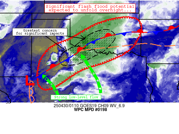
Mesoscale Precipitation Discussion 0198
NWS Weather Prediction Center College Park MD
927 PM EDT Tue Apr 29 2025

Areas affected...west Texas into much of Oklahoma

Concerning...Heavy rainfall...Flash flooding likely

Valid 300127Z - 300727Z

Summary...Flash flood threat continues across the discussion area
through 07Z and beyond.  Significant impacts are expected
especially across western north Texas and vicinity.

Discussion...Over the past 1-2 hours, a general uptick in
convection has been noted across much of Oklahoma and western
north Texas in tandem with 1) an increase of southerly low-level
flow across much of the southern Plains and 2) the complicated
evolution of a mature supercellular cluster currently just near
Wichita Falls.  Most of the convection has been slightly elevated
atop a cool/stable layer, but the aforementioned supercellular
cluster appeared to root near a remnant outflow from earlier
convection, with its complex evolution resulting in a few areas of
2-4 inch rainfall totals extending from just southeast of Lubbock
to near Seymour over the past 3-4 hours.  Convection continues to
grow upscale into a mix of lines and cells while also moving
through sensitive/wet ground conditions from prior extreme
rainfall across western north Texas and southwestern Oklahoma.
Occasional instances of flash flooding are expected with this
activity (extending into central/south-central Oklahoma) over the
next 2-4 hours.

Although a very brief break in precip coverage is apparent across
west Texas currently, 1) 40-45 knot 850mb flow across southwest
Texas, 2) nearly stationary surface boundaries, and 3) apparent
ascent over the TransPecos will result in another round of renewed
convection across west Texas that will migrate east-northeastward
across sensitive areas that have received abundant rainfall over
the past week (western North Texas into southern/central
Oklahoma).  Potential exists for a significant, widespread flash
flood event to unfold across these areas over the next 6 hours and
beyond.

Cook

ATTN...WFO...AMA...FWD...LUB...MAF...OUN...SJT...TSA...

ATTN...RFC...ABRFC...WGRFC...NWC...

LAT...LON   36559630 36539492 35869448 34909480 34029556
            33249716 32539920 31130148 31390243 33050238
            34280149 34979995 36019812
Download in GIS format: Shapefile
| KML
Last Updated: 927 PM EDT Tue Apr 29 2025
