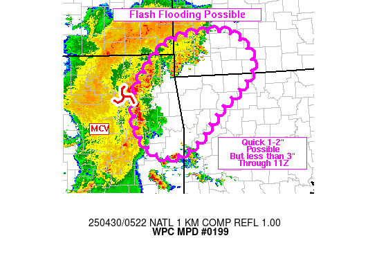
Mesoscale Precipitation Discussion 0199
NWS Weather Prediction Center College Park MD
124 AM EDT Wed Apr 30 2025

Areas affected...northeastern OK, northwestern AR, southwestern
MO, far southeastern KS

Concerning...Heavy rainfall...Flash flooding possible

Valid 300523Z - 301100Z

Summary...Some flash flooding will be possible across portions of
northeastern OK into the Ozarks through 11Z. A quick 1 to 2+
inches of rain (but less than 3") may occur with peak rates in
excess of 1 in/hr.

Discussion...05Z radar imagery showed an MCS moving through
east-central OK with an MCV apparent just southwest of Tulsa.
MRMS-derived peak rainfall rates have been 1-2 in/hr since 03Z but
the coverage of these rates has been decreasing and cloud tops
have experienced some warming over the past 1-2 hours. However,
30-40 kt of southerly flow at 850 mb (KINX VAD wind) has been
helping to advect instability northward with 04Z SPC mesoanalysis
data showing a gradient of 500 to just over 1000 J/kg MUCAPE
extending west-east from northeastern OK into northwestern AR with
areas showing limited or zero CIN. Farther south along the
southern OK/AR border, scattered thunderstorms were observed to be
increasing in coverage and intensity over the past hour.

As the MCV tracks toward the northeast, the leading edge of the
MCS will move into northeastern OK through 07Z while the small
cluster of thunderstorms along the southern OK/AR border likely
continues to translate northward with some possible continued
increase in coverage/intensity. Heavy rain will also move into
southwestern MO, but it appears the northern edge of instability,
represented by 500-1000 J/kg MUCAPE, will not make it much north
of a Joplin to Springfield line, which should limit rainfall
intensity with northward extent.

Brief training and cell mergers will have the potential to produce
rainfall rates of 0.5 to 1.5 in/hr, and a quick 1 to 2+ inches,
but with totals likely remaining below 3 inches through 11Z across
portions of northeastern OK into northwestern AR and southwestern
MO, representing a decent section of the Ozarks, as the MCS
advances downstream. The northern edge of the MCS is expected to
weaken as it encounters a lack of better instability over central
MO but farther south, some localized flash flooding will be
possible through 11Z.

Otto

ATTN...WFO...LZK...SGF...TSA...

ATTN...RFC...ABRFC...LMRFC...MBRFC...NWC...

LAT...LON   37379299 36569251 35659352 35059407 34759478
            34969537 35629572 36469552 37309457
Download in GIS format: Shapefile
| KML
Last Updated: 124 AM EDT Wed Apr 30 2025
