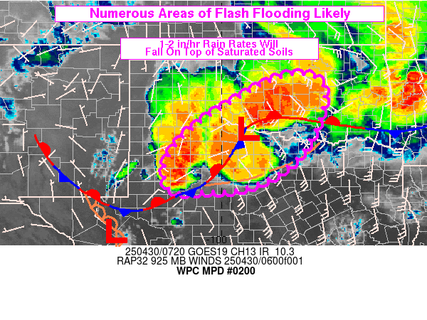
Mesoscale Precipitation Discussion 0200
NWS Weather Prediction Center College Park MD
333 AM EDT Wed Apr 30 2025

Areas affected...High to Rolling Plains of northwestern TX into
central OK

Concerning...Heavy rainfall...Flash flooding likely

Valid 300730Z - 301100Z

SUMMARY...Another round of heavy rain with embedded rainfall rates
of 1-2 in/hr will spread ENE across northwestern TX into central
OK over the next few hours. Given saturated soils from previous
heavy rainfall, numerous areas of flash flooding are expected
through 11Z.

DISCUSSION...Looping of MRMS reflectivity through 07Z showed
increasing thunderstorm coverage north of I-20 from about MAF to
ABI, to near AMA. These storms were forming north of a
quasi-stationary front draped through western TX, out ahead of a
shortwave located on water vapor imagery near the Guadalupe
Mountains...east of a larger-scale closed low over the AZ/NM
border. VWP data at 850 mb indicated southerly winds across
western TX of 40-50 kt, overrunning the well-defined frontal
boundary in place, beneath a diffluent and divergent upper level
jet pattern. In addition, a remnant outflow boundary was analyzed
from DYS to LUD to near DYI and was likely serving as a focus for
lift given the presence of a severe storm tracking ENE near
Albany.

Continued strong ascent will maintain the numerous coverage of
thunderstorms from the TX Panhandle into the Rolling Plains of
northwestern TX into central OK over the next few hours within
500-1500 J/kg MUCAPE (via SPC mesoanalysis and RAP forecasts).
This region of the southern Plains has received several rounds of
heavy rain over the past few days and large portions of the region
have saturated top layer soils, unable to absorb much in the way
of additional rainfall. A general movement of cells off toward the
northeast is expected but cell training will be common and
regeneration of cells will be possible near the intersection of
the outflow and frontal boundary to the north of DYS with locally
significant flooding possible anywhere cell training sets up atop
especially vulnerable locations given recent heavy rains. Rainfall
of 2 to 4 inches in 2-3 hours is expected in a few locations with
numerous areas of flash flooding likely.

Otto

ATTN...WFO...AMA...FWD...LUB...MAF...OUN...SJT...

ATTN...RFC...ABRFC...WGRFC...NWC...

LAT...LON   36029726 35769678 35399663 34139698 33029784
            32329918 32200055 32170158 32660186 33360172
            34440070 35809839
Download in GIS format: Shapefile
| KML
Last Updated: 333 AM EDT Wed Apr 30 2025
