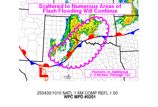
Mesoscale Precipitation Discussion 0201
NWS Weather Prediction Center College Park MD
612 AM EDT Wed Apr 30 2025

Areas affected...northwestern TX into central/northeastern OK

Concerning...Heavy rainfall...Flash flooding likely

Valid 301011Z - 301500Z

SUMMARY...Scattered to numerous coverage of flash flooding is
expected from portions of northwestern TX into central and
northeastern OK through 15Z. Rainfall rates of 1-2 in/hr (locally
higher) are likely to impact portions of the region which have
recently received heavy rainfall, potentially leading to
significant/considerable impacts.

DISCUSSION...Radar imagery at 10Z showed a forward propagating
line segment which extended from southwestern OK into northwestern
TX, located along and north of a quasi-stationary front which
draped southwestward from southern OK into the western Permian
Basin of TX. Peak MRMS-derived hourly rainfall with the advancing
line has generally been 1-2 inches. Over southern OK, a band of
training resulted in 2 to 5 inches of rain from northern Wilbarger
County, TX to Stephens County, OK, out ahead of the advancing line
segment. In addition, immediately in the wake of the forward
propagating line segment was an additional/small cluster between
MAF and LBB, slowly advancing eastward.

While some minor weakening of low level winds is expected over the
next few hours with the diurnal cycle, 25-45 kt of flow at 850 mb
is likely to maintain robust clusters of thunderstorms from
northwestern TX into central/northeastern OK over the next 3-5
hours. While line segments are expected to generally propagate
toward the east, there will be instances of training within the
line segments where orientation matches the SW to NE oriented
deeper layer steering flow. Rainfall rates of 1-2 in/hr will be
likely (locally higher) with an additional 2-4 inches through 15Z
for portions of the region. Due to areas of ongoing flash flooding
from recent heavy rainfall, scattered to numerous occurrences of
flash flooding are expected and locally significant/considerable
flooding could affect locations on either side of the Red River
which have picked up 4+ inches of rain over the past 12 hours.

Otto

ATTN...WFO...FWD...LUB...MAF...OUN...SJT...TSA...

ATTN...RFC...ABRFC...WGRFC...NWC...

LAT...LON   36369678 35909572 35239553 34019604 32449740
            31839848 31689945 31680041 31910100 32160138
            32310186 32550216 32960214 33430166 33780050
            34809961 35819813
Download in GIS format: Shapefile
| KML
Last Updated: 612 AM EDT Wed Apr 30 2025
