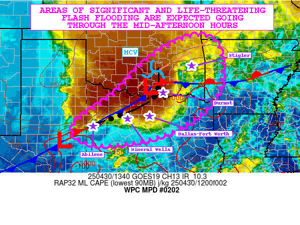
Mesoscale Precipitation Discussion 0202
NWS Weather Prediction Center College Park MD
1000 AM EDT Wed Apr 30 2025

Areas affected...Central and Northern TX...Eastern OK...Far
Western AR

Concerning...Heavy rainfall...Flash flooding likely

Valid 301400Z - 302000Z

SUMMARY...Very heavy showers and thunderstorms will be impacting
much of central and northern TX and into portions of eastern OK
and far western AR going through the mid-afternoon hours. Areas of
significant and life-threatening flash flooding are expected which
will include a notable urban flash flood threat to multiple
metropolitan areas including Dallas-Fort Worth and adjacent
suburbia.

DISCUSSION...The early morning GOES-E IR satellite imagery in
conjunction with dual-pol radar shows an elongated axis of very
heavy shower and thunderstorm activity focused across areas of
central and northern TX and extending well into areas of southern
and eastern OK. The convection is well organized and generally
focused along a quasi-stationary front with multiple waves of low
pressure riding east-northeast along it.

A look at the latest RAP analysis shows MLCAPE values of 1000 to
1500+ J/kg already pooled up along the front, with an increasingly
moist warm-sector airmass continuing to advance north into the
boundary with aid from a southerly low-level jet of 40 to 45+ kts.
3-hour MLCAPE differentials of +400 to +600 are already noted
along an axis from central TX to southeast OK along the corridor
of more convergent and moist low-level flow, and the combination
of higher surface dewpoints and diurnal heating will favor a
steady increase in instability over the next several hours.

The southern flank of the convective axis in particular from
central to northeast TX is expected to be particularly potent with
very high rainfall rate potential going forward as a combination
of strengthening thermodynamics and rather strong low to mid-level
shear (0-3 km bulk shear of 40 to 45 kts) favor enhanced/efficient
updrafts with substantial moisture convergence/water-loading
through the cloud-bearing layer. Rainfall rates of 2 to 3
inches/hour are likely in these areas.

Areas from especially the Mineral Wells to Dallas-Fort Worth
metropolitan corridor along with the adjacent suburbs of northern
TX (including the Denton to Sherman corridor) are expected to see
some of the heaviest rainfall rates and totals going through
mid-afternoon with as much as 3 to 5+ inches of rain possible
where localized corridors of cell-training occurs.

However, areas farther north into eastern OK are expected to see
additional heavy rainfall as a strong upstream MCV approaches and
interacts with the pooling of moisture/instability surging up
across southeast OK in close proximity to the aforementioned
front. Areas from Durant through McAlester and the Stigler
vicinity will likely see additional heavy rainfall totals of as
much as 2 to 4+ inches through this nowcast period.

Areas of significant and life-threatening flash flooding are
expected going through the mid-afternoon hours, and this will
include notable urban flash flooding concerns given the high
rainfall rate potential along with locally sensitive antecedent
conditions.

Orrison

ATTN...WFO...FWD...LUB...LZK...OUN...SHV...SJT...TSA...

ATTN...RFC...ABRFC...LMRFC...WGRFC...NWC...

LAT...LON   36609514 36199387 33929391 32249596 31619879
            31840029 32580048 33959863 35529709
Download in GIS format: Shapefile
| KML
Last Updated: 1000 AM EDT Wed Apr 30 2025
