| WPC Met Watch |
|
|
Mesoscale Precipitation Discussion: #0019 (2019) |
|
(Issued at 959 AM EST Sat Jan 19 2019
) |
|
| MPD Selection |
|
|
|
|
|

Mesoscale Precipitation Discussion 0019
NWS Weather Prediction Center College Park MD
959 AM EST Sat Jan 19 2019

Areas affected...Southwest Oregon...Far Northwest California...

Concerning...Heavy rainfall

Valid 191500Z - 200100Z

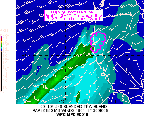
SUMMARY...Perisistent flow, narrowing moisture feed with little
variation continues to focus heavy rainfall into small area of SW
OR/N CA for the remainer of the day.

DISCUSSION...A classic flat atmospheric river remains highly
focused on the Klamath Range of SW Oregon and Coastal Northern
California with some bleed over to the Southern Oregon Cascades
throughout much of the day.  Current CIRA Layered PW suite and
NESDIS blended PW depict Total PWats in a narrow 1 degree wide
(60nmi) plume of 1.25" values that are mainly low level weighted.
A lull in flow noted currently but is enhancing back to 35kts over
the next few hours with an expected surge of .25-.5"/hr rates
reaching the N CA coast around 17-19z (RADAR already showing
increasing returns) for a few hours (3-4) associated with a subtle
wave and upper level jet divergence couplet.  After this wave
treks through, the gradient lessens and shifts south directing
more southerly flow, fracturing the remaining moisture plume and
reducing PWs below 1.25 to 1.0 by 21z and winds shifting more
southerly allowing the precipitation to drop south and reduce in
magnitude especially in the southwest facing orography that has
taken the brunt of this river over the last day or so.  As such an
additional 3-4" totals are expected across Del Norte, CA and SW
Curry county, where leading to 7-8" totals through the 30-36hr
event.  The best/only chance for flooding/fast river rises is
likely in the 17-21z time frame tappering after that.  Flash
flooding/mud slides are possible across the Taylor Creek/Klondike
burn scar.

Gallina

ATTN...WFO...EKA...MFR...

ATTN...RFC...CNRFC...NWRFC...

LAT...LON   43252285 42912219 42052265 41622310 41172344
            40822365 40612414 40622441 40892447 41362439
            41882444 42502466 42802463 42992403 43212336
Last Updated: 959 AM EST Sat Jan 19 2019
|


