| WPC Met Watch |
|
|
Mesoscale Precipitation Discussion: #0026 (2021) |
|
(Issued at 1112 PM EST Thu Feb 18 2021
) |
|
| MPD Selection |
|
|
|
|
|

Mesoscale Precipitation Discussion 0026
NWS Weather Prediction Center College Park MD
1112 PM EST Thu Feb 18 2021

Areas affected...Portions of GA/SC/NC

Concerning...Heavy rainfall...Flash flooding possible

Valid 190411Z - 191011Z

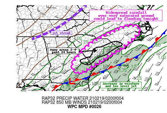
Summary...Rainfall overspreading portions of Georgia, South
Carolina, and North Carolina tonight will fall over areas that are
already saturated from previous rainfall. Totals of 1-2" are
possible and this could lead to additional flooding.

Discussion...Post-frontal moderate rainfall beginning to
overspread portions of the Southeast late this evening is driven
primarily from the approach of an upper-level trough and right
entrance jet streak. A weak surface wave will move up the coast
tonight where the latest forecast shows a resurgence of low-level
moisture transport and low-level jet peaking at 50 to 55 kts per
the latest RAP. This moisture increase combined with the forcing
should be enough to break out widespread moderate rainfall
overrunning the stationary boundary in place along/just offshore
the coast. The expected rainfall will fall over areas that
received 1-2" with local 4" amounts over the last 24 hours. The
main limiting factor for getting higher rain rates (1"/hr) will be
the lack of sufficient instability, as the 00Z HREF shows any
remaining MUCAPE confined to the extreme coastal areas.

Nonetheless, a stripe or narrow swath of locally heavy rainfall
between 1-2" will be possible through about 10Z given the
orientation of the mean flow with the storm motion resulting in
the potential of training clusters of rain. The 00Z HREF supports
some hourly totals above 0.5". This falling on top of areas that
are already well-saturated from today and the previous 2 weeks'
rainfall (anomalies 200-400%+) could result in rapid runoff and
flash flooding. Many streams/creeks are already swollen,
especially for portions of northeast SC and the coastal plain of
NC.

Taylor

ATTN...WFO...CAE...CHS...FFC...ILM...JAX...MHX...RAH...

ATTN...RFC...SERFC...NWC...

LAT...LON   35967736 35667666 34997727 34067831 33527925
            32688052 31708231 32368288 33038243 33808175
            34458093 35657859
Last Updated: 1112 PM EST Thu Feb 18 2021
|


