| WPC Met Watch |
|
|
Mesoscale Precipitation Discussion: #0026 (2022) |
|
(Issued at 724 PM EST Tue Jan 11 2022
) |
|
| MPD Selection |
|
|
|
|
|

Mesoscale Precipitation Discussion 0026
NWS Weather Prediction Center College Park MD
724 PM EST Tue Jan 11 2022

Areas affected...South Florida

Concerning...Heavy rainfall...Flash flooding possible

Valid 120024Z - 120624Z

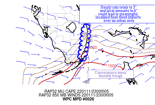
Summary...Thunderstorms have shown the tendency to cluster and
show slow movement as of late, leading to hourly totals to 3" per
radar estimates.  With local amounts to 6" possible where activity
sits for a couple hours, flash flooding could occur within their
urban environment.

Discussion...Organized showers and thunderstorms have formed
within an unstable environment caused by cool air moving over the
Gulf Stream -- ocean effect convection.  MU CAPE values (which
seem to well describe the ongoing convective coverage) are
500-1000 J/kg.  Low-level northeast flow of 15-20 kts is being
countered by the mean 850-400 hPa wind which is from the
west-northwest at similar magnitude.  This significant change of
the wind with height is leading to effective bulk shear of 25-40
kts which is organizing the activity, with the net motion a vector
addition of the two flows -- slowly southward.  A couple of
convective areas in northeast Miami-Dade and southeast Palm Beach
have been moving slowly lately, which has ramped up hourly rain
totals to 3" per radar estimates, despite precipitable water
values just over 1.25".

The 18z HREF probabilities of heavy rainfall (0.5"+ per hour, 3"+
per 12 hours) are quite high through the overnight hours within
this area.  The 5"/12 hour probabilities were a non-trivial
20-30%.  While slow moving clusters aren't expected to persist for
more than an hour or two as activity have been constantly shifting
and reorganizing, that would lead to the potential for local 6"
amounts overnight.  The northern end of the activity is expected
to slowly shift southward through eastern Palm Beach county with
the moisture and instability fields.  The threat appears isolated,
but over urban areas, could present a meaningful though localized
flash flood risk.

Roth

ATTN...WFO...KEY...MFL...MLB...

ATTN...RFC...SERFC...NWC...

LAT...LON   27068008 26928001 26687998 26258002 25828011
            25488017 25278027 25288040 25508041 25848035
            26398028 27038018
Last Updated: 724 PM EST Tue Jan 11 2022
|


