| WPC Met Watch |
|
|
Mesoscale Precipitation Discussion: #0050 (2023) |
|
(Issued at 538 AM EST Sun Jan 29 2023
) |
|
| MPD Selection |
|
|
|
|
|

Mesoscale Precipitation Discussion 0050
NWS Weather Prediction Center College Park MD
538 AM EST Sun Jan 29 2023

Areas affected...Southeast TX...Southwest to South-Central LA

Concerning...Heavy rainfall...Flash flooding possible

Valid 291038Z - 291638Z

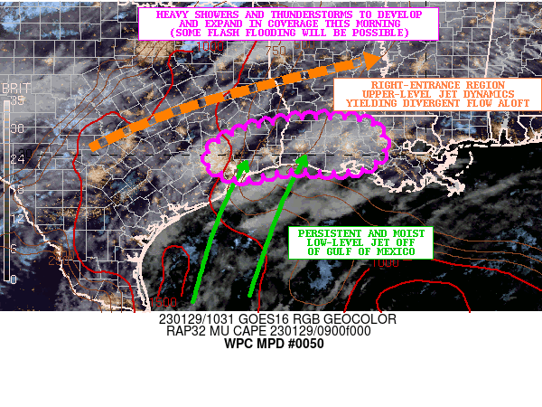
SUMMARY...Showers and thunderstorms will be developing and
expanding in coverage and intensity this morning across southeast
TX and into southwest to south-central LA. Some cell-training may
occur, with sufficient rainfall for some flash flooding to be
possible.

DISCUSSION...The environment is expected to become conducive for
areas of showers and thunderstorms to develop and expand in
coverage over the next few hours across the northwest Gulf Coast
region and including areas from the middle and upper TX coast
northeastward into southwest LA. Increasingly favorable low-level
convergence/forcing near and just inland of the coast will be
coupling with right-entrance region upper-level jet dynamics and
an improving thermodynamic environment for convection to expand in
coverage and intensity.

There is already a southerly low-level jet on the order of 30 to
40 kts yielding relatively strong moisture transport in off the
Gulf of Mexico. Meanwhile, strong southwest mid to upper-level
flow crossing Mexico with origins from the eastern tropical
Pacific Ocean is fostering the transport of vort energy embedded
within the subtropical jet along with a rather well-defined ribbon
of subtropical moisture. The latest CIRA-ALPW data suite depicts
this dual moisture transport regime with a convergence of moisture
streams noted toward the northwest Gulf Coast region.

There is a bit of uncertainty with where the strongest
concentration of convection will be this morning, but the better
overlap of forcing through the column relative to the stronger
instability axis would favor the southeast TX coastal plain
initially, but with gradually more expansion and organization in
time into southwest to south-central LA.

The 00Z/06Z HREF guidance support showers and thunderstorms
capable of producing rainfall rates of 1.5 to 2 inches/hour with
the aforementioned dual moisture feeds and persistent columnar
transport of moisture supporting enhanced convective rainfall
efficiency.

Despite uncertainties in the latest CAM guidance on the placement
of heaviest rainfall, the general expectation is that some
locations near or along the upper TX and over into southwest LA
will see as much as 3 to 4 inches of rain with locally higher
amounts by late morning, and some of this will be reflective of at
least occasional cell-training. Downstream areas of south-central
LA may also see similar amounts closer to midday.

Given the relatively moist soil conditions from the last heavy
rainfall event a few days ago, these additional rains will favor
sufficient runoff concerns for some flash flooding to be possible.
The urbanized locations including the Houston and
Beaumont/Port-Arthur metropolitan areas, and eventually Lake
Charles will also be sensitive to enhanced runoff potential.

Orrison

ATTN...WFO...HGX...LCH...LIX...

ATTN...RFC...LMRFC...WGRFC...NWC...

LAT...LON   30939287 30929203 30789140 30359111 29989117
            29639164 29569254 29639351 29399463 29479517
            29809566 30169556 30529498 30829396
Last Updated: 538 AM EST Sun Jan 29 2023
|


