| WPC Met Watch |
|
|
Mesoscale Precipitation Discussion: #0051 (2023) |
|
(Issued at 1056 AM EST Sun Jan 29 2023
) |
|
| MPD Selection |
|
|
|
|
|

Mesoscale Precipitation Discussion 0051
NWS Weather Prediction Center College Park MD
1056 AM EST Sun Jan 29 2023

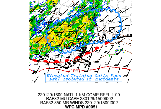
Areas affected...Southeast LA...Southern MS...Southwestern
AL...Far Western FL Panhandle..

Concerning...Heavy rainfall...Flash flooding possible

Valid 291555Z - 292100Z

SUMMARY...Training elevated cells may increase with efficiency
with better WAA into the afternoon.  Isolated incidents of flash
flooding may occur with prolonged training.

DISCUSSION...Regional RADAR mosaic depicts a well defined line of
enhanced shower and thunderstorm activity from St. Martin parish
staring to slide eastward out of MPD 50 toward the LA/MS border.
Low level veering in VWP network denotes veering of WAA emanating
from a warm, unstable Gulf environment.  Rain shield has been
reinforcing the gulf frontal zone to the coastal region of central
LA, and while a subtle shortwave at weak inflection in the right
entrance to the 120-130kt 3H jet streak near N M/TN, the WAA is
strong enough at this time to continue to support solid moisture
convergence to maintain the elevated cells within 250-500 J/kg of
MUCAPE but not enough to lift the FGEN zone northward.  Given
fairly unidirectional flow above 800mb, steering has supported
training elements capable of 1.5"/hr rates.  Eastward propagation
of the shortwave and active band, is modest, but the
aforementioned length, may allow for enhanced rainfall totals over
3-4" in localized narrow bands.

Ground conditions across E LA into S AL/W FL are a tad drier
through depth according to NASA SPoRT LIS relative soil moisture
ratio, reducing from 65% to 50%.  As such FFG values appear
reasonable, and so short-term rain rates of 1.5, perhaps up to 2"
are not likely to induced flash flooding; though the duration
across 2-3 hours is considered possible.

With time, WAA is expected to enhance and weak cold pool from the
elevated cells will further tighten and strengthen FGEN along a
potential developing outflow boundary/convective line.  Rates may
increase to 2" afternoon across S MS into AL and may start
becoming a hourly or sub-hourly flooding concern toward the 21z
time frame.

Gallina

ATTN...WFO...JAN...LIX...MOB...

ATTN...RFC...LMRFC...SERFC...NWC...

LAT...LON   31998815 31838717 31268691 30698712 30358772
            30338916 29979041 30219124 30909159 31469093
            31868934
Last Updated: 1056 AM EST Sun Jan 29 2023
|


