| WPC Met Watch |
|
|
Mesoscale Precipitation Discussion: #0052 (2023) |
|
(Issued at 1137 AM EST Sun Jan 29 2023
) |
|
| MPD Selection |
|
|
|
|
|

Mesoscale Precipitation Discussion 0052
NWS Weather Prediction Center College Park MD
1137 AM EST Sun Jan 29 2023

Areas affected...Southeast TX...Southwest to South-central LA...

Concerning...Heavy rainfall...Flash flooding possible

Valid 291635Z - 292200Z

SUMMARY...Potential for redeveloping thunderstorms along
front/coast capable of up to 2"/hr rates, with some training
possible into SW LA.  Very wet soils and prolonged rainfall
potential continue possible localized flash flooding risk into
this evening.

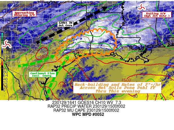
DISCUSSION...GOES-E WV suite depicts main shortwave crossing the
Big Bend of Texas as this time.  Downstream a subtle split in the
jet core along with favorable anticyclonic curvature is exiting
across the MS Valley supports weak ridging near the TX/LA boarder.
 This is lifting the warm/coastal front ever so slightly and
backing low level flow a bit over the next few hours to reduce
isentropic ascent over south-central LA.  However, this is also
supporting a reloading, strengthening of moisture convergence
further west where increased low level confluence aligned with the
curvature of the Mid-TX coast favors continued
back-building/redevelopment along the frontal zone southwest of
the Houston Metro, extending toward the Sabine River.  This warm
front lifting and slight cooling aloft from approaching
shortwave/height-falls is enhancing some instability in the
profile to support stronger deeper convection over the next few
hours.  MUCAPE of 1000 J/kg remains upstream to enhance these
cells.  CIRA LPW analysis also denotes an area of enhanced sfc to
700mb moisture across the middle to upper TX coast allowing for
values of 1.75" through the depth. Given convergence strength,
this should support 1.5"/hr rates throughout the area of concern,
though areas of enhanced lift or even weak rotation in the
mid-levels may allow for 2-2.25"/hr rates.

Aloft, steering flow remains fairly unidirectional to allow for
some potential of downstream training, this increases with time
across SW LA into the late afternoon as the shortwave continues to
shear into the confluent flow.  Hi-Res CAMS all support this idea
though confidence is lost a bit as they remain uncertain on
precise axis.  Totals of 3-4" are likely, with isolated 5"+ a
remote but still possible isolated occurrence through 22z.  This
morning's rainfall has helped to saturate the upper soil layers
and through 40cm, the relative saturation are well above normal
across SE TX, especially (80-90th percentile)... though the entire
region is running about 60-70% saturated.  As such, increased
runoff is possible in short-term increasing localized flash
flooding incidents.

Gallina

ATTN...WFO...HGX...LCH...SHV...

ATTN...RFC...LMRFC...WGRFC...NWC...

LAT...LON   31529329 31369228 30829185 30149190 29799249
            29789346 29479482 29099602 29419640 30009623
            30789532 31189444
Last Updated: 1137 AM EST Sun Jan 29 2023
|


