| WPC Met Watch |
|
|
Mesoscale Precipitation Discussion: #0065 (2019) |
|
(Issued at 1045 PM EST Fri Feb 22 2019
) |
|
| MPD Selection |
|
|
|
|
|

Mesoscale Precipitation Discussion 0065
NWS Weather Prediction Center College Park MD
1045 PM EST Fri Feb 22 2019

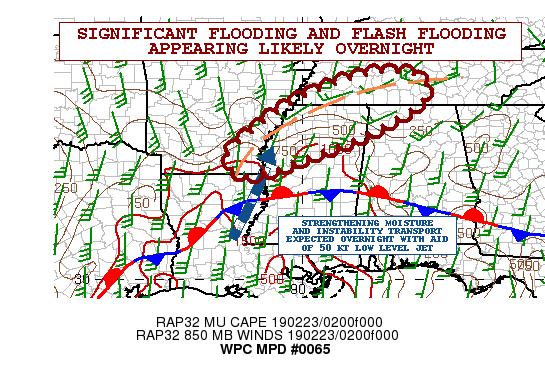
Areas affected...Southeast AR...Northern MS...Far Northwest
AL...Southwest to South-Central TN

Concerning...Heavy rainfall...Flash flooding likely

Valid 230345Z - 230945Z

Summary...There will be concerns for life-threatening/significant
flooding and flash flooding overnight as additional rounds of
heavy showers and thunderstorms arrive over exceedingly
wet/saturated soil conditions.

Discussion...The large scale synoptic pattern features a deep
trough and associated closed low beginning to exit the Four
Corners region and moving out across the southern High Plains.
Downstream of this is a deep layer warm advection pattern over the
Lower MS Valley with a strong subtropical jet oriented
southwest/northeast from the eastern Pacific up across the
northwest Gulf of Mexico and across the Mid-South. Meanwhile, a
quasi-stationary frontal zone is draped across the Gulf Coast
states.

There continues to be more than enough forcing in place for
numerous showers and thunderstorms across areas of the Lower MS
Valley and Mid-South as persistent southwest low level flow in the
850/925 mb overruns the front and transports plenty of moisture
and instability in an elevated fashion. Additionally, much of this
region is situated underneath favorable right-entrance region jet
dynamics which is fostering deep layer ascent in conjunction with
favorable thermodynamics.

The latest radar imagery is showing heavy showers and
thunderstorms beginning to gradually become better
organized/focused again over areas of southeast AR and up across
northern MS. Cloud top cooling seen in GOES-16 IR satellite
imagery is suggestive of stronger forcing and most likely related
to not only an increase in divergent flow aloft, but also
strengthening of the low level jet.

Hires models from the 00Z cycle, including numerous runs of the
HRRR, support an axis of training showers and thunderstorms going
through 09Z across especially areas of southeast AR, northern MS,
and into areas of southwest to south-central TN. This will be
supported by largely unidirectional flow in the 850/500 mb layer,
but one major contributing factor to the rainfall threat overnight
will be the increasing low level jet which is forecast to reach
upwards of 50 kts across northern MS by 09Z. Enhanced moisture
transport will result from this and the PWATs are forecast to rise
to locally over 1.75 inches.

Radar trends tend to favor the QPF axis of the 00Z ARW and last
couple runs of the HRRR a bit more versus the 00Z ARW2/NAM-conest
solutions, and the MPD threat area closely follows a consensus of
these solutions for this period.

Very heavy rainfall totals overnight are expected, with as much as
an additional 3 to 5 inches of rain expected. In fact, the latest
HREF probabilistic output favors rainfall rates approaching 2
inches/hr within the stronger convective elements.

Unfortunately, the soil conditions are saturated and there are
already locally significant runoff problems/flooding ongoing. The
additional rainfall tonight will only exacerbate the situation
further and it appears that life-threatening/significant flooding
and flash flooding will be likely. Will continue to monitor the
situation closely.

Orrison

ATTN...WFO...BMX...HUN...JAN...LZK...MEG...OHX...

ATTN...RFC...LMRFC...OHRFC...SERFC...

LAT...LON   35938753 35908693 35718653 35168654 34568742
            33978862 33488996 33149081 32979163 33189202
            33589211 34079162 35009039 35528923 35868815
Last Updated: 1045 PM EST Fri Feb 22 2019
|


