| WPC Met Watch |
|
|
Mesoscale Precipitation Discussion: #0099 (2019) |
|
(Issued at 618 PM EDT Thu Mar 14 2019
) |
|
| MPD Selection |
|
|
|
|
|

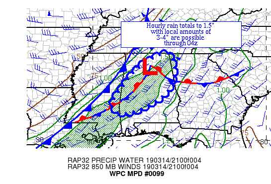
Mesoscale Precipitation Discussion 0099
NWS Weather Prediction Center College Park MD
618 PM EDT Thu Mar 14 2019

Areas affected...Central AL

Concerning...Heavy rainfall...Flash flooding possible

Valid 142217Z - 150417Z

Summary...Convection across AL is becoming increasingly aligned
with the mean flow and beginning to slow down its eastern
progress.  Hourly rain totals to 1.5" with local amounts to 3-4"
are expected.

Discussion...Organized convection across central AL appears to be
slowing down its eastward progression as it becoming increasingly
aligned along the axis of the mean 850-400 hPa wind.  Water vapor
imagery shows a deep cyclone moving north-northwest of the region
and a weak shortwave moving across AR which is spurring some
additional development behind the primary thunderstorm line.  The
upstream instability pool across southern MS and southeast LA has
nearly halted its eastward progress over the past couple hours.
ML CAPE within the pool are 1000-2000 J/kg.  Precipitable water
values of 1.25-1.5" lie across the region per GPS data.  Inflow at
850 hPa is 35-50 kts from the southwest per VAD wind profiles,
near the magnitudes of the mean 850-400 hPa wind and the effective
bulk shear.

Increased training potential appears to be in the cards over the
next several hours before instability weakens and the frontal zone
catches up to the convective area.  Mesocyclone formation also
would be a cause of heavy rainfall within this area.  The
development of CIN just after sunset could also lead to some
stalling of the convective line in 2-3 hours.  The 18z HREF
probabilities of 1"+ an hour ramp up over the next four hours due
to the combination of the above factors before fading thereafter.
Until the cold front catches up to the convective line, hourly
rain totals up to 1.5" and local amounts up to 3-4" (as advertised
by the mesoscale guidance) are expected.  Although rainfall across
the area has been somewhat below average over the past couple
weeks, the storm totals expected could challenge area flash flood
guidance values and would be problematic in urban areas.

Roth

ATTN...WFO...BMX...FFC...HUN...JAN...MOB...MRX...

ATTN...RFC...LMRFC...SERFC...

LAT...LON   34988567 33718533 32548599 31578795 32008888
            33108821 34238726
Last Updated: 618 PM EDT Thu Mar 14 2019
|


