| WPC Met Watch |
|
|
Mesoscale Precipitation Discussion: #0120 (2020) |
|
(Issued at 209 PM EDT Fri Apr 03 2020
) |
|
| MPD Selection |
|
|
|
|
|

Mesoscale Precipitation Discussion 0120
NWS Weather Prediction Center College Park MD
209 PM EDT Fri Apr 03 2020

Areas affected...South-Central Texas

Concerning...Heavy rainfall...Flash flooding possible

Valid 031806Z - 040006Z

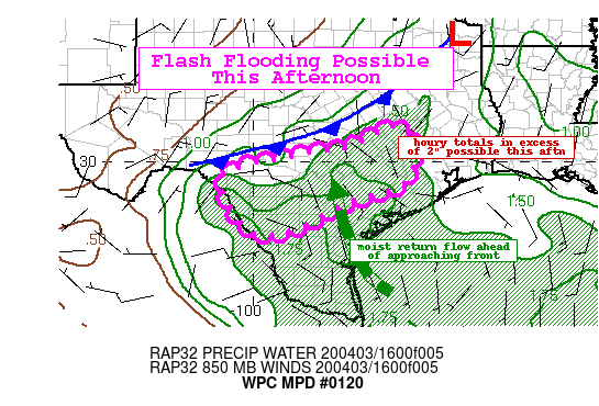
Summary...Localized flash flooding will be possible this afternoon
as a slow moving cold front interacts with a seasonably
moist/unstable air mass. Hourly rain totals exceeding 2" will be
possible.

Discussion...Latest surface analysis shows a cold front draped
across from near the Arklatex region southwest through the central
Texas hill country. Ahead of this boundary, the air mass is
characterized by dewpoints in the upper 60s and lower 70s.
Satellite imagery reveals a blanket of stratus present. The most
recent PW analysis shows values around 1.3-1.5", which is between
2 and 3 standard deviations above the climatological normal.

The expectation is that with daytime heating, the shallow stratus
should begin to erode, giving way to MLCAPE values of 1500 to 2500
J/kg by early afternoon. Current radar imagery already shows
convection firing up across the western areas of south-central
Texas where the better instability resides. With the approaching
cold front, the low level convergence should be on the increase
and with sufficient large scale forcing for ascent from the exit
region of the subtropical jet, isolated to scattered convection is
expected to spread further east toward east-central TX. The RAP
forecast is showing the best focus for heavy rainfall (combination
of moisture/instability/low-level convergence) to shift southward
with the front steadily into the early evening hours which should
allow the storms to move along. Nonetheless, the mean flow is
somewhat oriented parallel to the expected storm motion and this
could favor some training storms.

Storms that do develop will have the potential for hourly totals
in excess of 2". The 12Z HREF shows probabilities for exceeding 1"
in 1-hour in the 60-80 percent range this afternoon with at least
a moderate signal for 2" in 1-hour (30-50 percent) for several
hours across south-central to central TX. 6-hour totals ending at
00Z could reach 3" in localized places.

Recent rainfall in the outlook area has led to a positive rainfall
departure over the last 14 days with many areas experiencing
150-200 percent of normal. As such, although the latest FFGs show
high values (1-hr guidance is mostly at or above 2-2.5"), where
convection repeats there could be a localized flash flood threat
through this afternoon and early evening.


Taylor

ATTN...WFO...CRP...EWX...FWD...HGX...

ATTN...RFC...WGRFC...

LAT...LON   30959625 30299579 29849586 29379625 28849782
            28289888 28140003 29600083 30119905 30429745
Last Updated: 209 PM EDT Fri Apr 03 2020
|


