| WPC Met Watch |
|
|
Mesoscale Precipitation Discussion: #0136 (2023) |
|
(Issued at 1018 PM EDT Sun Mar 26 2023
) |
|
| MPD Selection |
|
|
|
|
|

Mesoscale Precipitation Discussion 0136
NWS Weather Prediction Center College Park MD
1018 PM EDT Sun Mar 26 2023

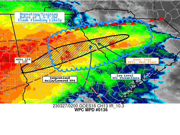
Areas affected...East-central GA... West-central SC...

Concerning...Heavy rainfall...Flash flooding likely

Valid 270215Z - 270730Z

SUMMARY...Initially slow moving thunderstorms along the warm front
pose localized flash flooding risk before upstream cells arrive
producing training/mergers and continuing flash flooding risk
through early morning hours.

DISCUSSION...GOES-E IR depicts overshooting tops breaking through
the cirrus debris from larger upstream complex.  These widely
scattered to scattered thunderstorms are developing along the
preceding pressure trof where sfc winds have backed slightly with
fairly solid confluence across central SC into eastern GA.  This
generally aligns with a step increase of low level moisture where
Tds increase to mid-60s and may be considered the edge of the warm
front, even though upstream height-falls have lead to southern
winds and increasing Tds across the Upstate as well.  This is also
aligned with increasingly unidirectional flow per VWP at JGX and
FFC out of the southwest at 25-30kts.  This higher theta-E air
aloft, still has sufficient buoyancy for 500-1000 J/kg and 1.3 to
1.5" total PWats to allow for efficient rainfall production.
Rates of 1.5-2"/hr are probable within the regime.

Currently, steering flow is unidirectional to support a favorable
training environment to wash over the region in the next few hours
as greater convective coverage associated with subtle shortwave
reaches the area.  However, the backed low level flow and
approaching height-falls has supported a col in the flow to allow
for slower cell motions, particularly even weak rotating updrafts
in the vicinity.  This will allow for increased duration of these
efficient rates and has the potential for 2-3" totals in the
short-term period and widely scattered incidents of flash
flooding.  Given early morning thunderstorms with 1-3" totals from
Putnam, GA to Aiken/Lexington, SC have compromised soils flash
flooding is considered likely as FFG values have been compromised
to well less than 1.5"/hr and 2.5"/3hrs.

Flash flooding incidents are going increase in probability from
west to east as the areal coverage of stronger updrafts become
numerous while also likely to train/repeat through the same axis
along and north of the trof axis/frontal zone.  Additional 2-3"
totals may result in isolated spots of 4" and flash flooding will
continue to be likely especially along the compromised soil
axis/Fall Line.

Gallina

ATTN...WFO...CAE...FFC...GSP...

ATTN...RFC...SERFC...NWC...

LAT...LON   34718115 34588037 33888024 33418125 33048218
            32918305 32898377 33728407 34098398 34398322
            34578221
Last Updated: 1018 PM EDT Sun Mar 26 2023
|


