| WPC Met Watch |
|
|
Mesoscale Precipitation Discussion: #0160 (2019) |
|
(Issued at 936 PM EDT Wed Apr 24 2019
) |
|
| MPD Selection |
|
|
|
|
|

Mesoscale Precipitation Discussion 0160
NWS Weather Prediction Center College Park MD
936 PM EDT Wed Apr 24 2019

Areas affected...Arklatex Region

Concerning...Heavy rainfall...Flash flooding possible

Valid 250135Z - 250735Z

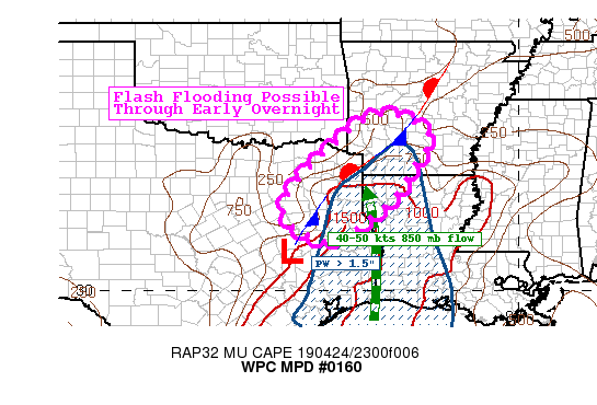
Summary...Flash flooding will be possible through the early
overnight hours across portions of northeast Texas, southwest
Arkansas, and northwest Louisiana.

Discussion...Thunderstorms continue early this evening across much
of the Arklatex region associated with an area of low pressure
centered northeast of Austin. A stationary front arcs
northeastward through Arkansas where a focused area of
thunderstorms has been producing hourly rates as high as 2" with
some of the convective clusters per radar returns from KSHV.
Aloft, water vapor imagery shows a mid/upper level feature moving
through central Texas, putting the region in the favored region
for large scale forcing for ascent.

Through 07z, convection will continue to move northeast into
portions of Arkansas. Instability is expected to remain
sufficient, with MUCAPE values currently of 2000 J/kg expected to
remain at least 1000-1500 J/kg through 07z. The low-level jet will
increase somewhat, to around 40-45 kts, nosing in PWs of around
1.5". Mean flow is somewhat parallel to storm motion, which could
favor some training convection.

Hi-res models show the potential for hourly totals of 1-2" (recent
observation from nearby mesonet of 1.33") and total amounts as
high as 3-4" in local areas. This could exceed the local FFG
values and 14-day departure from normal is running 200-300
percent. So, this additional rainfall could lead to localized
flash flooding through the early overnight hours.

Taylor

ATTN...WFO...FWD...HGX...LZK...SHV...

ATTN...RFC...ABRFC...LMRFC...WGRFC...

LAT...LON   34589330 34379271 33959230 33359267 32449328
            31339475 31589574 32079610 32969565 34399410
Last Updated: 936 PM EDT Wed Apr 24 2019
|


