| WPC Met Watch |
|
|
Mesoscale Precipitation Discussion: #0173 (2021) |
|
(Issued at 712 PM EDT Tue May 11 2021
) |
|
| MPD Selection |
|
|
|
|
|

Mesoscale Precipitation Discussion 173
NWS Weather Prediction Center College Park MD
712 PM EDT Tue May 11 2021

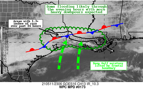
Areas affected...Southeast TX...South-Central LA

Concerning...Heavy rainfall...Flash flooding likely

Valid 112310Z - 120500Z

Summary...Widespread slow moving showers and thunderstorms are
expected to develop and persist through the evening hours.
Flooding is likely to be an issue where multiple rounds of slow
moving storms develop through midnight local time, with rainfall
rates of 2-3 inches per hour possible.

Discussion...Latest regional Doppler radar imagery is indicating
an increase of convection across portions of southwestern
Louisiana, and a large MCS approaching from east-central Texas.
This is all happening in the general vicinity of a
quasi-stationary frontal boundary that is expected to remain
anchored in place.   Lift will further be aided by increasing
mid-upper level divergence and strong boundary layer moisture
convergence.  These storms will have plenty of fuel available with
PWs rising into the 2.0 to 2.3 inch range based on recent
guidance, with ML CAPE in the 1500-2500 J/kg range near the
Interstate 10 corridor.

The latest CAM guidance suite is suggesting the potential for
additional 3-5 inch rainfall totals during the outlook period, and
some of this is likely to occur over highly saturated soils along
with much above normal stream flows.  Much of the region has been
hammered with heavy rain recently, with portions of the outlook
area receiving 300% of normal rainfall over the past 7 days, and
this has considerably lowered flash flood guidance values.
Therefore, some instances of flash flooding are likely through
midnight.

Hamrick

ATTN...WFO...HGX...JAN...LCH...LIX...SHV...

ATTN...RFC...LMRFC...WGRFC...NWC...

LAT...LON   31339435 31339331 31239190 31179139 31059083
            30959038 30579012 30078998 29829008 29689051
            29549110 29539189 29559257 29739310 29709376
            29489444 29299493 29449540 29659576 29909598
            30159606 30319621 30589619 30779609 31069576
            31259542 31259512 31309474
Last Updated: 712 PM EDT Tue May 11 2021
|


