| WPC Met Watch |
|
|
Mesoscale Precipitation Discussion: #0178 (2022) |
|
(Issued at 1154 AM EDT Sat May 07 2022
) |
|
| MPD Selection |
|
|
|
|
|

Mesoscale Precipitation Discussion 0178
NWS Weather Prediction Center College Park MD
1154 AM EDT Sat May 07 2022

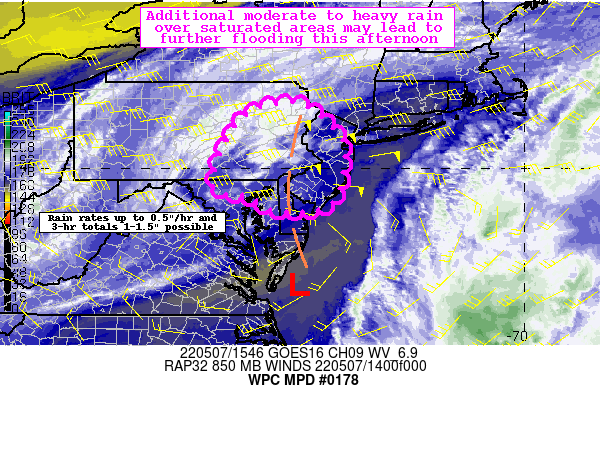
Areas affected...Portions of the Mid-Atlantic

Concerning...Heavy rainfall...Flash flooding possible

Valid 071554Z - 072154Z

Summary...Steady moderate rain through the afternoon over areas
that are increasingly saturated may lead to additional excessive
runoff and flooding, particularly for poor drainage, low lying,
and urban areas. Isolated totals between 1-1.5" are possible
through the late afternoon.

Discussion...As of 1545Z, the closed mid-level low was centered
over central Maryland with a surface low positioned off the coast
of southeast Virginia. This combination is giving way to favorable
diffluence aloft and low level convergence with strong easterly
low level flow. 850 mb winds per the latest VWP and RAP forecasts
show the near 50 kts currently are expected to continue through
the afternoon. Regional radar shows a very large shield of
moderate rain nearly stationary or slowly pivoting across the
Mid-Atlantic and much of the outlook area has seen widespread
heavy rainfall in the last 24-36 hours. Many areas have reported
1-2" with localized 3-4" totals, especially across portions of
northern MD into southern to southeast PA. As a result, the ground
has become increasingly saturated and recent NASA SPoRT show
relative soil moisture above 70 percent in the top 100 cm layer
and streamflows are running much above normal.

The 12Z hi-res guidance is in reasonably good agreement showing a
continuation of the pivoting rain bands in the onshore flow across
the coastal Mid-Atlantic. Rain rates up to 0.5"/hr and isolated
maximum 3-hr totals between 1-1.5" are possible. This additional
rainfall falling over areas that are already saturated with very
low flash flood guidance (3-hr values as low as 1" and 1-hr FFG as
low as 0.5") could easily lead to excessive runoff and additional
flooding concerns through the afternoon particularly for the poor
drainage, low-lying, and urban areas.

Taylor

ATTN...WFO...BGM...CTP...LWX...OKX...PHI...

ATTN...RFC...MARFC...NERFC...NWC...

LAT...LON   41537537 40907446 40327420 39177450 38987572
            39357650 39587727 41107666
Last Updated: 1154 AM EDT Sat May 07 2022
|


