| WPC Met Watch |
|
|
Mesoscale Precipitation Discussion: #0251 (2022) |
|
(Issued at 646 PM EDT Wed May 25 2022
) |
|
| MPD Selection |
|
|
|
|
|

Mesoscale Precipitation Discussion 0251
NWS Weather Prediction Center College Park MD
646 PM EDT Wed May 25 2022

Areas affected...southeast MS, western AL

Concerning...Heavy rainfall...Flash flooding possible

Valid 252245Z - 260400Z

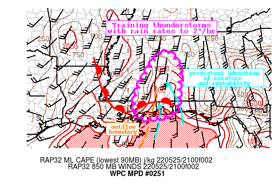
Summary...Showers and thunderstorms expanding along an eastward
moving outflow boundary will train to the north with rain rates of
up to 2"/hr. This could produce 2-3" of rainfall atop already
saturated soils. Flash flooding is possible.

Discussion...The regional radar mosaic depicts a slowly eastward
advancing outflow boundary along which thunderstorms have been
intensifying this evening. This is noted by an increase in
coverage of both high reflectivity on KMOB WSR-88D, and cooling
cloud tops on the GOES-E IR imagery. Recent radar estimates of
rainfall rates have reached 1.5"/hr in southeast MS, and this is
occurring across areas that have received 2-5" of rainfall in the
past 24-hrs according to MRMS and mesonet observations. This
recent rainfall has saturated the soils, leaving locally
compromised FFG which is as low as 0.75"/1hr and 1-2"/3hrs.

As this outflow boundary continues to shift eastward, it will
encounter favorable thermodynamics to support continued heavy
rainfall. Recent GPS observations indicate PWs are as high as 1.7"
near the AL/MS border, near the 90th percentile for the date,
collocated with a ribbon of SPC RAP MLCape of 1000-2000 J/kg
surging northward from the Gulf of Mexico. This combination of
moisture and instability will continue to be resupplied by nearly
unidirectional southerly flow evident on forecast soundings, with
850mb winds reaching 20-30 kts lifting 14C dew points northward.
As the outflow boundary shifts eastward, it is likely that
convection will continue to develop along this confluence axis,
with additional lift possible just inland as the southerly flow
isentropically ascends a wavering warm front draped from west to
east.

The high-res guidance has struggled today, and is generally
under-doing the current radar coverage. However, recent runs of
the NAMnest and HRRR have increased their convective coverage and
rainfall forecasts through the evening, and the HREF probability
for 2"/hr rain rates are as high as 30%. As convection likely
regenerates across the Gulf and lifts northward, training of cells
is likely within the unidirectional flow, offsetting what should
be generally fast cell motion on 0-6km mean winds of 20-30 kts.
Training of 2"/hr rain rates could produce 2-3" of rainfall in the
next few hours, with locally higher amounts. This rain could occur
atop soils pre-conditioned by heavy rainfall in the past 24-hrs,
which is reflected by HREF exceedance probabilities for 1, 3, and
6-hr FFG reaching 20-40%. Where this heavy rain trains across the
already moist soils, flash flooding is possible.


Weiss

ATTN...WFO...BMX...JAN...LIX...MOB...

ATTN...RFC...LMRFC...SERFC...NWC...

LAT...LON   33768797 33678748 33168719 32698704 31788713
            31198713 30768719 30458731 30298755 30178794
            30138829 30078863 30048896 30118926 30368946
            30468952 31218953 32328906 32708883 33398844
Last Updated: 646 PM EDT Wed May 25 2022
|


