| WPC Met Watch |
|
|
Mesoscale Precipitation Discussion: #0252 (2022) |
|
(Issued at 1206 AM EDT Thu May 26 2022
) |
|
| MPD Selection |
|
|
|
|
|

Mesoscale Precipitation Discussion 0252...Corrected
NWS Weather Prediction Center College Park MD
1206 AM EDT Thu May 26 2022

Corrected for Threat Level

Areas affected...Florida Panhandle into south-central Alabama

Concerning...Heavy rainfall...Flash flooding possible

Valid 260356Z - 260800Z

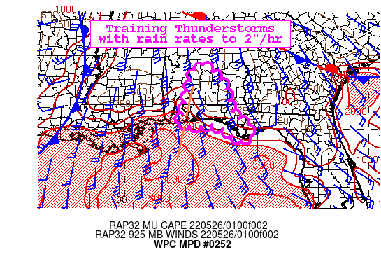
Summary...Thunderstorms drifting east into the Florida Panhandle
will continue to train along with further activity spreading in
from the Gulf east through Apalachicola with rain rates of up to
2"/hr. This could produce 2-3" of rainfall atop already saturated
soils. Flash flooding is possible.

Discussion...Regional radar depicts a slowly eastward advancing
broken line of thunderstorms near the western FL/AL border into
south-central AL. GOES-E IR imagery depicts cooling cloud tops
continuing over far western FL Panhandle with additional
development over the Gulf spreading east through Cape San Blas
where intermittent heavy rain has been ongoing since this
afternoon. KMOB continues to depict hourly rainfall estimates of
2" near the western FL/AL border with past 3hr gauge reports of 2
to 3.5" rainfall in AL east of Mobile Bay. This is occurring
across areas that have received 4-6" rainfall in the past few days
from AHPS and 72hr gauge readings. Despite soils being fairly
saturated over the FL Panhandle, 3hr FFG is still 3 to 5".

Favorable thermodynamics ahead of this activity will continue to
support heavy rainfall. Recent GPS observations indicate PWs are
1.8" to 2" near the AL/FL border with an axis of 1000-2000 J/kg
MUCAPE shifting inland from the Gulf of Mexico. This combination
of moisture and instability will continue to be resupplied by
nearly unidirectional southerly low flow, allowing redevelopment.

CAMs continue to struggle with this activity with recent HRRRs
seemingly under-doing the FL Panhandle potential. Further
development is expected farther west later tonight ahead of the
approaching cold front which is likely to impact areas of
southeast LA/southern MS/AL already hit with heavy rain over the
past 12 hrs, but this ongoing threat farther east warrants its own
discussion. Instability does diminish quickly inland fromt he
coast including near Cape San Blas which has seen a decrease in
rates over the past half hour. However, the continued advection
off the Gulf should keep this area farther east on the FL
Panhandle with a heavy rain threat for several more hours.


Jackson

ATTN...WFO...BMX...MOB...TAE...

ATTN...RFC...SERFC...NWC...

LAT...LON   32588671 31768588 30608555 30298503 30008489
            29668485 29538527 30148620 30118726 30208774
            31048749 32468714
Last Updated: 1206 AM EDT Thu May 26 2022
|


