| WPC Met Watch |
|
|
Mesoscale Precipitation Discussion: #0253 (2022) |
|
(Issued at 444 AM EDT Thu May 26 2022
) |
|
| MPD Selection |
|
|
|
|
|

Mesoscale Precipitation Discussion 0253
NWS Weather Prediction Center College Park MD
444 AM EDT Thu May 26 2022

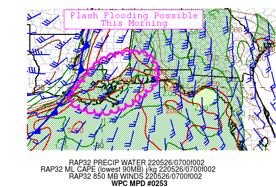
Areas affected...Central Gulf Coast

Concerning...Heavy rainfall...Flash flooding possible

Valid 260830Z - 261330Z

Summary...Thunderstorms will continue to develop as they track
northeast ahead of a cold front across southeast Louisiana and
into southern Mississippi and Alabama through mid-morning. Hourly
rainfall up to 2"/hr may develop with 3"/3hr possible. Flash
flooding is possible.

Discussion...Scattered thunderstorms are developing ahead of a
cold front currently pushing through south-central LA and western
MS. GOES-E IR imagery depicts cooling cloud tops over the northern
Gulf of Mexico ahead of an upper trough axis associated with an
upper low over southeast KS. PWs of 1.5 to 1.7" will continue to
spread northeast from southeast LA per recent RAP runs and MLCAPE
of 1500 to 2000 J/kg will surge northeast into MS/AL on 30kt SWly
850mb flow. This combined with deep layer SWly flow that raises
the risk for repeating cells with 2" hourly rainfall of 2" and 3"
likely in areas this morning. This portion of the central Gulf
Coast has had a few rounds of heavy rain over the past few days
making the area more susceptible to flash flooding, particularly
from Mobile to Pensacola which saw 1-4" of heavy rain this past
evening.

CAMs have depicted pre-frontal activity to spread northeast from
southeast LA and given the large scale dynamics at play there is
little doubt that at least locally heavy rain will continue to
develop and spread over the central Gulf Coast through the
mid-morning. Flash flooding possible. The flash flood threat is
likely to continue farther east later this morning, so be on the
lookout for subsequent downstream discussions.


Jackson

ATTN...WFO...JAN...LCH...LIX...MOB...

ATTN...RFC...LMRFC...SERFC...NWC...

LAT...LON   31798909 31788746 30318708 28738947 29249167
            30489089 31409007
Last Updated: 444 AM EDT Thu May 26 2022
|


