| WPC Met Watch |
|
|
Mesoscale Precipitation Discussion: #0254 (2022) |
|
(Issued at 545 AM EDT Thu May 26 2022
) |
|
| MPD Selection |
|
|
|
|
|

Mesoscale Precipitation Discussion 0254
NWS Weather Prediction Center College Park MD
545 AM EDT Thu May 26 2022

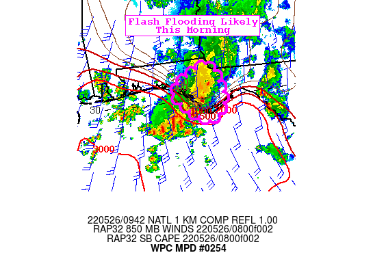
Areas affected...Florida Panhandle

Concerning...Heavy rainfall...Flash flooding likely

Valid 260944Z - 261344Z

Summary...Thunderstorms will once again spread inland between
Apalachicola and Panama City, bringing more intermittent heavy
rain to this portion of the Florida Panhandle that has received 4
to 7 inches over the past 20 hours of continuous rainfall. Flash
flooding is likely over the most sensitive areas between Cape San
Blas and Panama City.

Discussion...Numerous thunderstorms that have lingered southwest
of Cape San Blas have once again become surface-based and started
shifting across the coast early this morning. Strong Sly low level
flow ahead of an approaching cold front will allow moisture and
surface based instability to shift inland through the mid-morning
hours. GOES-E IR imagery depicts cooling cloud tops once again
over the northern Gulf just off Cape San Blas that extend onshore.
PWs of 1.8 to 1.9" will be reinforced in the southerly flow with
recent RAP runs allowing SBCAPE to expand inland through the
mid-morning hours. This area has received rainfall in 20
consecutive hours with intermittent heavy rain featured yesterday
afternoon and evening before being limited to offshore overnight.


CAMs continue to struggle with this activity with recent HRRRs
still failing to retain the ongoing cluster for more than a couple
hours. However, given the potential for 2"/hr rainfall over this
very saturated area, flash flooding is likely through the
mid-morning hours. With the approaching cold front not expected to
cross this section of the FL Panhandle until late tonight, there
is plenty of more potential for heavy rain and further flooding
today.


Jackson

ATTN...WFO...TAE...

ATTN...RFC...SERFC...NWC...

LAT...LON   30828490 30168464 29708467 29448520 30208601
            30638552
Last Updated: 545 AM EDT Thu May 26 2022
|


