| WPC Met Watch |
|
|
Mesoscale Precipitation Discussion: #0257 (2022) |
|
(Issued at 305 PM EDT Thu May 26 2022
) |
|
| MPD Selection |
|
|
|
|
|

Mesoscale Precipitation Discussion 0257
NWS Weather Prediction Center College Park MD
305 PM EDT Thu May 26 2022

Areas affected...Upper Midwest from northeast Missouri through
southern Wisconsin

Concerning...Heavy rainfall...Flash flooding possible

Valid 261904Z - 270100Z

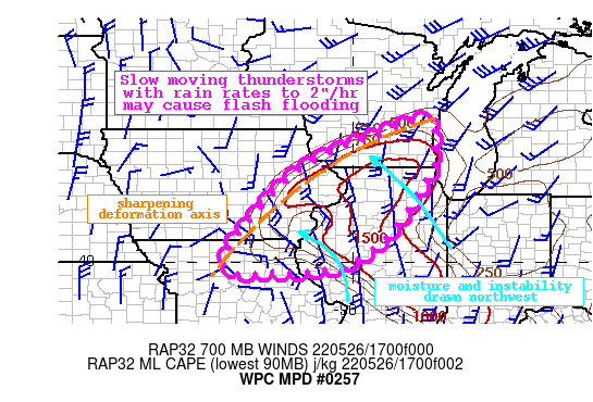
Summary...Showers and thunderstorms will increase in coverage
across the Upper Midwest with rain rates of 2"/hr likely at times.
Slow movement of these storms could produce 2-3" of rain with
locally higher amounts. Flash flooding is possible.

Discussion...The GOES-E WV imagery this aftn clearly depicts a
strong closed low centered over Missouri with an impressive
moisture plume surging northward from the Gulf of Mexico. This
plume is characterized by PWs as measured by GPS observations of
1-1.2", above the 75th percentile for the date. The WPC surface
analysis indicates a stationary boundary near the IL/IA border,
with a triple point northwest of St. Louis, MO extending from an
occlusion beneath the upper low. A modest warm sector has
developed south of this stationary front with SPC RAP MLCape
analyzed to be over 1000 J/kg, which is combining with increasing
deep layer ascent to fuel rapid expansion of convection this aftn
with rain rates of 1-1.5"/hr as estimated by KILX and KDVN radars.

As the upper low pivots slowly eastward, the cold front extending
from the triple point will shift northeast into the favorable
thermodynamics of high PW and instability. Additionally,
impressive mid-level theta-e advection within a cyclonically
pivoting TROWAL will extend into the Upper Midwest to enhance
instability and moisture into the evening. This should allow for
widespread showers and thunderstorms to develop across northern IL
and then pivot N/NW on 0-6km mean winds of 10-20 kts. As storms
lift N/NW, they will encounter what is progged to become an
impressive deformation axis north of the occluded cyclone, further
enhancing lift, but also leading to a slowing of storm motions
into this axis. This is is reflected both by high-res simulated
reflectivity and Corfidi vectors forecast to fall to around 5 kts,
leading to a QPF footprint that may maximize from far northeast MO
into far southern WI. The combination of training of cells from
S/SE to N/NW and then slowing, with rain rates that are likely to
reach 2"/hr at times according to HREF probabilities, could
produce 2-3" of rain with locally higher amounts.

AHPS 7-day rainfall has been mostly below normal across this area,
and NASA SPoRT soil moisture is generally near normal. However,
there exist pockets of 3-hr FFG compromised to as low as
1.5"/3hrs, which the HREF suggests has a better than 30% chance of
being exceeded. Where the lowest FFG exists, the flash flood risk
is greatest, but any of these slow moving storms could produce
instances of flash flooding through this evening.


Weiss

ATTN...WFO...ARX...DMX...DVN...EAX...ILX...LOT...LSX...MKX...

ATTN...RFC...MBRFC...NCRFC...NWC...

LAT...LON   43758820 43738783 43498785 43208789 42858786
            42538787 41178872 40558923 40019001 39829072
            39759153 39769240 39719256 39729309 40229333
            42129173 42939038 43398914
Last Updated: 305 PM EDT Thu May 26 2022
|


