| WPC Met Watch |
|
|
Mesoscale Precipitation Discussion: #0263 (2022) |
|
(Issued at 1025 AM EDT Sat May 28 2022
) |
|
| MPD Selection |
|
|
|
|
|

Mesoscale Precipitation Discussion 0263...Corrected
NWS Weather Prediction Center College Park MD
1025 AM EDT Sat May 28 2022

Corrected for typo in last paragraph

Areas affected...northern Mid-Atlantic into southern New York/New
England

Concerning...Heavy rainfall...Flash flooding possible

Valid 281416Z - 282015Z

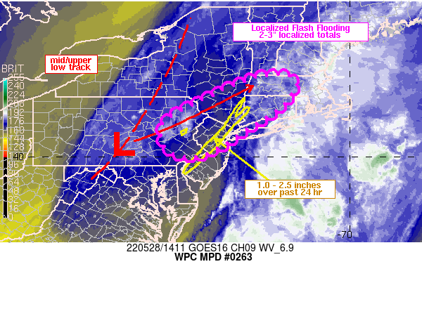
Summary...Slow moving showers and thunderstorms are expected to
impact portions of the northern Mid-Atlantic into southern New
York/New England through late afternoon. Rainfall rates of 1-2
in/hr are expected with localized totals in the 2-3 inch range.
Flash flooding will be possible, especially where heavy rain fell
over the past 24 hours from PA into NJ and southern NY.

Discussion...Regional radar imagery through 1345Z showed an
increase in showers/thunderstorms across eastern PA, just ahead of
a closed low centered over south-central PA. Instability remained
fairly weak this morning across the region, with only about
250-500 J/kg MLCAPE on the 13Z SPC mesoanalysis from eastern PA
into NJ and southeastern NY, but area precipitable water values
ranged from about 1.2 to 1.5 inches via recent GPS measurements.
Deeper-layer mean winds beneath the upper low/trough axis are
weak, in the 10-15 kt range.

While cloud cover is prevalent across the Northeast this morning,
the 12Z sounding from ALB and area RAP analysis soundings to the
south suggest that temperatures only need to warm into the low to
middle 70s to reach their convective temperature. Forecasts from
the RAP indicate some degree of westerly low level flow combined
with the mean westerly flow aloft will support slow storm movement
at times between 5-15 kt along with some brief repeating of cells.
Instability should remain weak though, with recent RAP forecasts
showing 500-1000 J/kg MLCAPE through 20Z.

The combination of precipitable water values between 1.2 and 1.5
inches and slow storm motions should support rainfall rates of 1-2
in/hr and perhaps some localized 2-3 inch totals. Given hydrologic
sensitivity from yesterday's rainfall, mostly over eastern PA into
northern NJ and southern NY, flash flooding may result, with areas
of heavy rain shifting eastward into southern New England in the
17-20Z time frame. Areas downstream into CT and central/western MA
haven't been as wet in recent days/weeks which should limit flash
flood potential across eastern portions of the MPD threat area,
but localized runoff issues cannot be ruled out.

Otto

ATTN...WFO...ALY...BGM...BOX...CTP...GYX...OKX...PHI...

ATTN...RFC...MARFC...NERFC...NWC...

LAT...LON   42727269 42727227 42657189 42357178 41907209
            41617233 41017331 40127474 40097583 40567624
            41057624 41327598 41707528 42297403 42637320
Last Updated: 1025 AM EDT Sat May 28 2022
|


