| WPC Met Watch |
|
|
Mesoscale Precipitation Discussion: #0328 (2021) |
|
(Issued at 749 PM EDT Thu Jun 10 2021
) |
|
| MPD Selection |
|
|
|
|
|

Mesoscale Precipitation Discussion 0328
NWS Weather Prediction Center College Park MD
749 PM EDT Thu Jun 10 2021

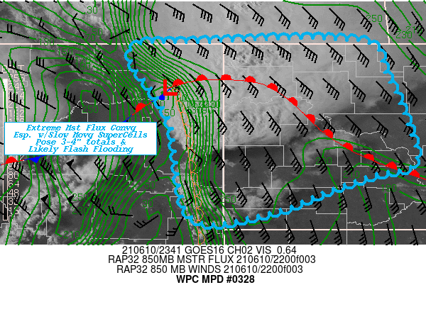
Areas affected...Far Northeast MT...Western ND...

Concerning...Heavy rainfall...Flash flooding likely

Valid 102350Z - 110530Z

SUMMARY...Initial slow moving supercell cluster with enhanced low
level moisture flux convergence should support high rain rates
over low FFG to pose possible flash flooding.

DISCUSSION...Sub 996mb low NE of OLF continues to deepen with a
sharp dry line extending due south with anomalously high moisture,
mid-60s Tds east of it though low 70s values pooled in the
Missouri River Valley along the warm front that crosses from the
surface low into far NW ND before dropping south to KHIE and KY19.
 Low level flow is extremely strong with sfc 25-30kts and 50-60kts
from the SSE at 850mb.  While moisture is fairly shallow per
special soundings out of BIS and UNR, the CIRA LPW 850-7H layer is
still over .75" which combined with the winds is near 5-6 Standard
Anomalies from normal and is expected to increase through the
evening.   The shear mass loading of moisture should quickly
moisten the profile in/near ongoing cells further increasing
rainfall efficiency.

Currently, a cluster of supercells along the warm front and
southward to near K20U have a primary threat of Hail and
tornadoes, but there is also a growing threat of heavy rainfall
and potential for flash flooding.  RAP analysis Bunker's Rgt
moving propagation vectors are about 20-30 kts slower than mean
steering flow and this can be seen by the slow eastward
progression before main height-falls press dryline and propagation
eastward by 02-03z.   So in the short-term 1.25" PWats will
compile and with enhanced moisture flux due to supercell nature,
values will increase to near 1.75" in the next few hours with
similar rainfall rates perhaps even exceeding 2"/hr.  Given
short-term slow motions, this may allow for totals to reach 3-4"
particularly with the southern most storm.  FFG values in the
region would be exceeded by these hourly rates and with 3hr rates
1.5-2.5" with isolated pockets less than that, flash flooding is
becoming likely.   RADAR/Visble imagery depict Additional elevated
upstream development likely per HRRR/RAP   expanding across NE MT
with an additional round.  As such, will consider flash flooding
likely overall by 06z with some 3-4" totals probable, though
likely to be highly focused in one or two smaller areas within the
MPD area.

While MRMS is likely contaminated with hail returns and over
inflated rain rates, even at 50% estimates would be approaching
FFG values, as current OU Flash QPE/FFG ratios are nearing 200%
with Max Unit stream flow response particularly in E Richland, MT
and western McKenzie county, ND.

Gallina

ATTN...WFO...BIS...BYZ...GGW...

ATTN...RFC...MBRFC...NCRFC...NWC...

LAT...LON   49040181 48520137 47670099 47030088 46850156
            46540244 46240322 46150454 47780491 48870556
            49020439
Last Updated: 749 PM EDT Thu Jun 10 2021
|


