| WPC Met Watch |
|
|
Mesoscale Precipitation Discussion: #0382 (2023) |
|
(Issued at 659 PM EDT Mon May 29 2023
) |
|
| MPD Selection |
|
|
|
|
|

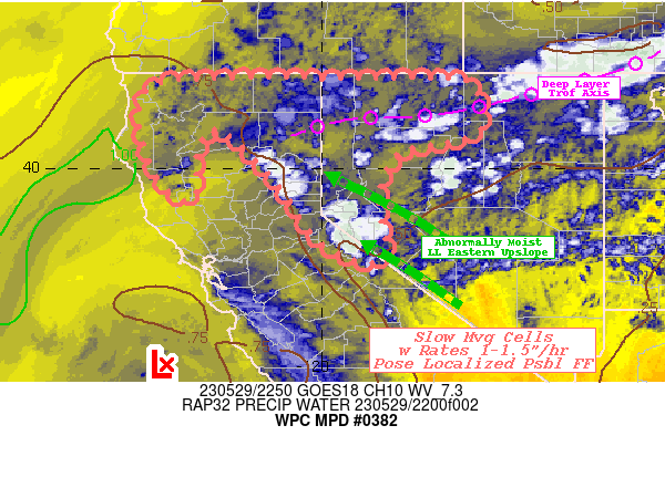
Mesoscale Precipitation Discussion 0382...Corrected
NWS Weather Prediction Center College Park MD
659 PM EDT Mon May 29 2023

Corrected for Wording in second last sentence in first paragraph

Areas affected...Northern California...Northwest Nevada

Concerning...Heavy rainfall...Flash flooding possible

Valid 292235Z - 300415Z

SUMMARY...Well above average moisture, favorable upper-level
pattern and slow cell motions across complex terrain poses
scattered incidents of flash flooding through evening.

DISCUSSION...GOES-W WV loop shows deep compact closed low off the
Central West Coast of California with a highly diffluent pattern
across the central and northern Sierra Nevada Range, particularly
over the eastern slopes into North Central Nevada.  Well above
normal (2-2.5 Std Dev) deep layer moisture remains pooled along
the eastern slopes of the Range with total PWat values over .7"
though 1" values exist in the northern Sacramento Valley as
through the northerly return flow regime out of W OR across far NW
coastal CA.  Strong solar heating across the range sparked an
above normal upslope mountain flow and with moist low levels, CAPE
up to 1000 J/kg and the convergence has sparked scattered
thunderstorm development in the best diffluence region near Lake
Tahoe, increasing with time toward the north into Lassen and
northern Washoe counties.  Moisture flux convergence is solid and
should support rates of 1-1.25"/hr.  Inital motions have been very
slow with the first updrafts allowing for increased rainfall to
fall with some highly focused spots of 1-1.5" likely adding to
increased runoff due to snow melt.  As such, in/near these down
drafts, it is possible to induce flash flooding and/or rock slides
(especially on the drier eastern slopes, where erosion is less
common).  Given weak steering, rain may fall in on the initial
updrafts or cold pool generation should spur outflow.  New strong
development is likely to spout on outflow boundaries, and cell
motions should likely keep overall totals in the .5-1" range given
forward motions.

Further Northwest across the Trinity/Siskiyou Ranges, a bit more
heating is necessary as upper-level support is a bit less
favorable. However, cells across Lake county will spring up first
as there is modest divergence in the entrance to the 65kt 3H jet
north and northwest of the closed low.  This outflow aloft should
support stronger updrafts that should spread northward with time.
Slow cell motions and slightly increased moisture flux (due to
availability) should support similar 1-1.25"/hr rates and spots of
1-1.5" totals are possible.  Given the rain-forest nature of the
region, the rates will be key here for inducing flash flooding, as
so will be limited to the cores of the downdrafts, particularly if
they can stay anchored to slopes due to combined easterly and
westerly upslope flow.

Gallina

ATTN...WFO...EKA...LKN...MFR...REV...STO...

ATTN...RFC...CNRFC...NWRFC...NWC...

LAT...LON   41892181 41881942 41881743 41681678 40841665
            40541734 40311840 39311881 38281861 38001880
            38201965 38702027 39722098 40822216 40332265
            39352268 39602332 40792381 41712356
Last Updated: 659 PM EDT Mon May 29 2023
|


