| WPC Met Watch |
|
|
Mesoscale Precipitation Discussion: #0428 (2020) |
|
(Issued at 158 AM EDT Sun Jul 5 2020
) |
|
| MPD Selection |
|
|
|
|
|

Mesoscale Precipitation Discussion 428
NWS Weather Prediction Center College Park MD
158 AM EDT Sun Jul 5 2020

Areas affected...Northeast TX...Southeast OK...Southwest
AR...Northwest LA

Concerning...Heavy rainfall...Flash flooding possible

Valid 050557Z - 051200Z

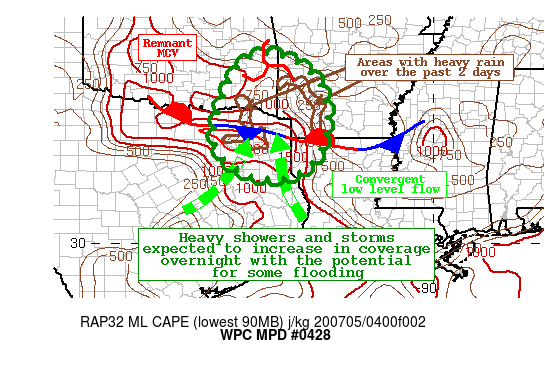
Summary...Scattered to numerous heavy showers and thunderstorms
are likely during the overnight hours.  The slow movement and high
rainfall rates will create a potential flooding threat through 7
am local time.

Discussion...GOES-16 water vapor imagery and RAP model 700 mb
winds confirm the existence of a weak MCV located over east
central Oklahoma, and this is progged to slowly move southward
over the next several hours.  A convergent low level inflow over a
quasi-stationary front will aid in focusing moisture convergence
over the ArkLaTex region, with the mid level vortmax further
aiding in ascent over the outlook area.  Precipitable water values
have increased to near two inches based on the latest SPC
mesoanalysis, and a reservoir of mixed layer CAPE on the order of
1500 to 2500 J/kg south of the developing convection over far
northeast Texas as of 1 am will keep to sustain this convection
and enhance rainfall rates.

There is good overall agreement in the high-res guidance for
patches of 2 to 4 inch rainfall amounts by sunrise, with isolated
higher totals possible.  Parts of this region have already
received 1 to 2 inches of rain over the past 48 hours, and thus
these areas are slightly more vulnerable to flooding.  With the
potential for hourly rainfall rates to exceed two inches per hour
at times, flash flooding is possible.

Hamrick

ATTN...WFO...FWD...LZK...OUN...SHV...TSA...

ATTN...RFC...ABRFC...LMRFC...WGRFC...NWC...

LAT...LON   35409493 35289414 34799345 34139309 33249309
            32579329 32059380 31899445 32009532 32469600
            33119626 33889607 34619580 35129549
Last Updated: 158 AM EDT Sun Jul 05 2020
|


