| WPC Met Watch |
|
|
Mesoscale Precipitation Discussion: #0443 (2023) |
|
(Issued at 925 PM EDT Wed Jun 07 2023
) |
|
| MPD Selection |
|
|
|
|
|

Mesoscale Precipitation Discussion 0443
NWS Weather Prediction Center College Park MD
925 PM EDT Wed Jun 07 2023

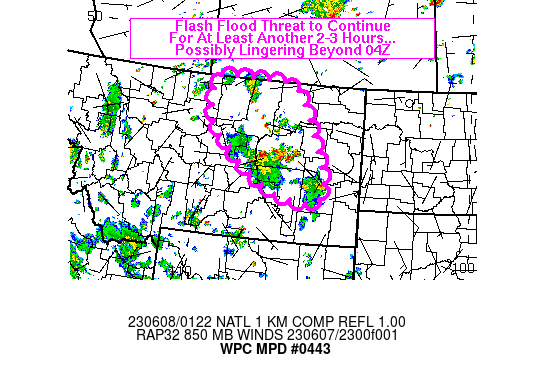
Areas affected...northeastern quadrant of MT

Concerning...Heavy rainfall...Flash flooding likely

Valid 080120Z - 080700Z

SUMMARY...Areas of flash flooding appear likely to continue for
portions of the northeastern quadrant of MT through 04Z, with a
possible threat continuing beyond 04Z. Rainfall rates of 1-2
inches in 30-60 minutes are expected.

DISCUSSION...Regional radar imagery over eastern MT at 01Z showed
scattered thunderstorms focused over east-central MT, between I-94
and just north of the Missouri River near Fort Peck Lake. While
the presence of hail may be causing MRMS-rainfall estimates to be
a bit too high, MRMS suggests 1-2 inches in 30 to 60 minutes has
occurred with some of the stronger cells over the past few hours.
Numerous outflow boundaries were observed on KGGW radar imagery,
surging toward the west and about to converge in the vicinity of
the Phillips/Garfield county line. MLCAPE near 850 J/kg was
observed on the 00Z GGW sounding along with 1.2 inches of PW (near
climatological max for June 7/8) and 7 C/km 700-500 mb lapse
rates. SPC mesoanalysis data from 01Z showed locally higher CAPE
(1000+ J/kg) over portions of northeastern MT.

A short term flash flood threat will continue where storms are in
the process of merging with a flare up of convection likely as new
updrafts form within the area of enhanced surface convergence.
Easterly/upslope flow to the immediate east of this region will
help to sustain widely scattered convection in the short term as
well given the lingering instability. Continued and locally
enhanced low level easterly winds may continue a localized flash
flood threat to the east and southeast of the expected dissipation
of merging cells (located to the west) later in the overnight. Low
flash flood guidance values of about 1 inch (1 and 3 hour
duration) are fairly widespread across the discussion area,
contributing to the likelihood of additional flash flooding in the
short term. Rainfall rates of 1-2 inches in 30-60 minutes with
additional storm totals of 3 or 4 inches are expected through 07Z.

Otto

ATTN...WFO...BYZ...GGW...TFX...

ATTN...RFC...MBRFC...NWC...

LAT...LON   49020952 49010843 48990694 48820659 48480631
            47050553 46300533 46030579 46090664 46240725
            46460770 46890847 47540938 47740959 48690978
Last Updated: 925 PM EDT Wed Jun 07 2023
|


